
Perth Amboy topographic map
Click on the map to display elevation.
About this map
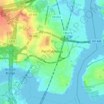
Name: Perth Amboy topographic map, elevation, terrain.
Average elevation: 13 m
Minimum elevation: -4 m
Maximum elevation: 52 m
Other topographic maps
Click on a map to view its topography, its elevation and its terrain.
Lawrence Brook Manor
United States > New Jersey > Middlesex County > East Brunswick Township
Average elevation: 19 m
North Stelton
United States > New Jersey > Middlesex County > Piscataway Township
Average elevation: 29 m
Elmer B Boyd Park
United States > New Jersey > Middlesex County > New Brunswick > Feaster Park
Average elevation: 22 m
Orchard Heights
United States > New Jersey > Middlesex County > East Brunswick Township
Average elevation: 32 m
Frost Woods Park
United States > New Jersey > Middlesex County > East Brunswick Township
Average elevation: 29 m
Middlesex Downs
United States > New Jersey > Middlesex County > Monroe Township
Average elevation: 33 m
Possumtown
United States > New Jersey > Middlesex County > Piscataway Township
Average elevation: 19 m
Randolphville
United States > New Jersey > Middlesex County > Piscataway Township
Average elevation: 26 m
Paulas Corners
United States > New Jersey > Middlesex County > East Brunswick Township
Average elevation: 29 m
Randolphville
United States > New Jersey > Middlesex County > Piscataway Township
Average elevation: 26 m
Woodbridge
United States > New Jersey > Middlesex County > Woodbridge Township
Average elevation: 16 m
North Stelton
United States > New Jersey > Middlesex County > Piscataway Township
Average elevation: 29 m
Lynn Woodoaks
United States > New Jersey > Middlesex County > Woodbridge Township > Colonia
Average elevation: 31 m
Sand Hills
United States > New Jersey > Middlesex County > Woodbridge Township > Fords
Average elevation: 24 m
Fieldville
United States > New Jersey > Middlesex County > Piscataway Township
Average elevation: 17 m
Prospect Plains
United States > New Jersey > Middlesex County > Monroe Township
Average elevation: 39 m
Berdines Corners
United States > New Jersey > Middlesex County > North Brunswick
Average elevation: 29 m
South River
United States > New Jersey > Middlesex County > South River > South River
Average elevation: 19 m
Highland Park
United States > New Jersey > Middlesex County > Highland Park > Highland Park
Average elevation: 24 m