
Neukölln topographic map
Interactive map
Click on the map to display elevation.
Neukölln
Neukölln lies on the geological border between the shallow Berliner Urstromtal glacial valley and the Tempelhofer Berge, which are situated in the northernmost region of the Teltow ground moraine plateau, rising to the south of Hermannplatz, in what is mostly the typical low-lying marshy woodlands with a mainly flat topography of the North European Plain.
About this map
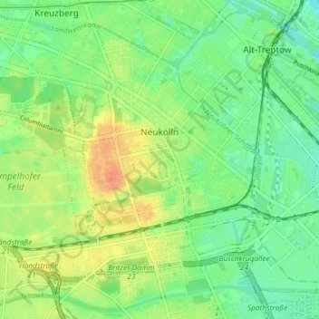
Name: Neukölln topographic map, elevation, terrain.
Location: Neukölln, Berlin, Germany (52.45876 13.40608 52.49587 13.47855)
Average elevation: 43 m
Minimum elevation: 26 m
Maximum elevation: 67 m
Other topographic maps
Click on a map to view its topography, its elevation and its terrain.
Viktoriapark
On the occasion of the elevation of the monument ideas appeared to lay out a park around it. Two years later the design of a park was put out to tender. Hermann Mächtig (*1837-1909*), since 1877 Berlin's city garden director, handed in a design, already using the name Victoria Park, in honour of Princess…
Average elevation: 45 m