
Thanh Phu District topographic map
Interactive map
Click on the map to display elevation.
About this map
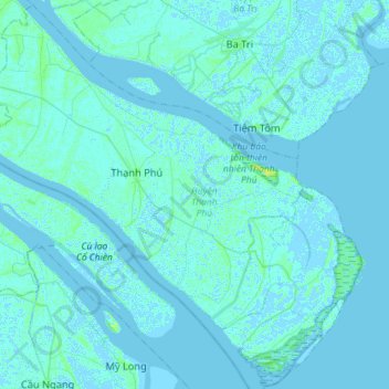
Name: Thanh Phu District topographic map, elevation, terrain.
Location: Thanh Phu District, Bến Tre Province, Vietnam (9.79398 106.39977 10.07064 106.68694)
Average elevation: 1 m
Minimum elevation: -3 m
Maximum elevation: 12 m
Other topographic maps
Click on a map to view its topography, its elevation and its terrain.
Xã Bình Khánh
Vietnam > Bến Tre Province > Mỏ Cày Nam District
Xã Bình Khánh, Mỏ Cày Nam District, Bến Tre Province, Vietnam
Average elevation: 3 m
Xã Bình Thạnh
Vietnam > Bến Tre Province > Thanh Phu District
Xã Bình Thạnh, Thanh Phu District, Bến Tre Province, Vietnam
Average elevation: 1 m
Chau Thanh
Vietnam > Bến Tre Province > Chau Thanh District
Chau Thanh, Chau Thanh District, Bến Tre Province, 86000, Vietnam
Average elevation: 3 m
Long Thành
Vietnam > Bến Tre Province > Giồng Trôm District
Long Thành, Giồng Trôm District, Bến Tre Province, Vietnam
Average elevation: 3 m
Tân Tây
Vietnam > Bến Tre Province > Chau Thanh District
Tân Tây, Chau Thanh District, Bến Tre Province, 86309, Vietnam
Average elevation: 2 m
Tanh Phú Đông
Vietnam > Bến Tre Province > Tanh Phú Đông
Tanh Phú Đông, Giồng Trôm District, Bến Tre Province, Vietnam
Average elevation: 3 m