
Hull topographic map
Interactive map
Click on the map to display elevation.
About this map
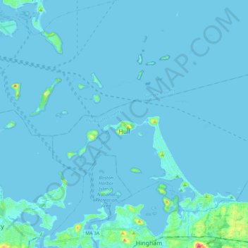
Name: Hull topographic map, elevation, terrain.
Location: Hull, Plymouth County, Massachusetts, 02045, United States (42.25853 -70.96048 42.35360 -70.77918)
Average elevation: 2 m
Minimum elevation: -4 m
Maximum elevation: 60 m
Other topographic maps
Click on a map to view its topography, its elevation and its terrain.
West Meadow
United States > Massachusetts > Plymouth County > West Bridgewater
Average elevation: 29 m
Great Herring Pond
United States > Massachusetts > Plymouth County > Plymouth > Cedarville
Average elevation: 24 m
Peddocks Island
United States > Massachusetts > Plymouth County > Hull > Fort Andrews
Average elevation: 1 m
Arthur Thurbur Land
United States > Massachusetts > Plymouth County > Duxbury > Baileys Corner
Average elevation: 18 m
Scotland Estates
United States > Massachusetts > Plymouth County > Bridgewater
Average elevation: 28 m
Fresh Pond
United States > Massachusetts > Plymouth County > Plymouth > Cedar Bushes
Average elevation: 14 m
Marshfield Hills
United States > Massachusetts > Plymouth County > Marshfield > Marshfield Hills
Average elevation: 29 m
Indian Heights
United States > Massachusetts > Plymouth County > Wareham > Indian Heights
Average elevation: 8 m
Cranberry Village
United States > Massachusetts > Plymouth County > Carver > Cranberry Village
Average elevation: 30 m
Kent Park
United States > Massachusetts > Plymouth County > Marshfield > Kent Park
Average elevation: 13 m
Green Harbor River
United States > Massachusetts > Plymouth County > Marshfield > Green Harbor
Average elevation: 2 m