
Berloz topographic map
Interactive map
Click on the map to display elevation.
About this map
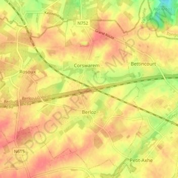
Name: Berloz topographic map, elevation, terrain.
Location: Berloz, Waremme, Liège, Wallonia, 4257, Belgium (50.68359 5.16510 50.72365 5.23538)
Average elevation: 124 m
Minimum elevation: 89 m
Maximum elevation: 141 m
Other topographic maps
Click on a map to view its topography, its elevation and its terrain.
Hollogne-sur-Geer
Hollogne-sur-Geer, Geer, Waremme, Liège, Wallonia, 4250, Belgium
Average elevation: 129 m