
King Island Council topographic map
Interactive map
Click on the map to display elevation.
About this map
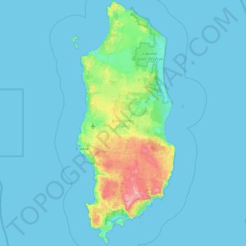
Name: King Island Council topographic map, elevation, terrain.
Location: King Island Council, Tasmania, 7256, Australia (-40.16220 143.81817 -39.57885 144.16430)
Average elevation: 14 m
Minimum elevation: 0 m
Maximum elevation: 159 m
Other topographic maps
Click on a map to view its topography, its elevation and its terrain.
Mount Wellington
"... In many parts the Eucalypti grew to a great size, and composed a noble forest. In some of the dampest ravines, tree-ferns flourished in an extraordinary manner; I saw one which must have been at least twenty feet high to the base of the fronds, and was in girth exactly six feet. The fronds forming the…
Average elevation: 941 m