
Alamagan Island topographic map
Interactive map
Click on the map to display elevation.
About this map
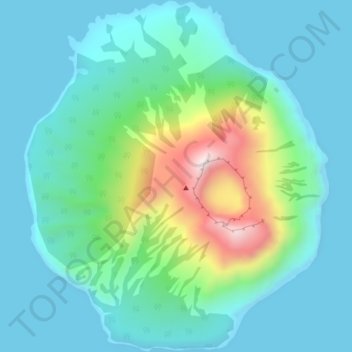
Name: Alamagan Island topographic map, elevation, terrain.
Average elevation: 148 m
Minimum elevation: 0 m
Maximum elevation: 710 m
Other topographic maps
Click on a map to view its topography, its elevation and its terrain.
Saipan
United States > Northern Mariana Islands > Saipan Municipality > Garapan
Saipan, the largest island in the Northern Mariana Islands, features a diverse and rugged topography shaped by volcanic activity. The island's central region is dominated by Mount Tapochau, its highest peak at 1,553 feet (474 meters), providing a dramatic backdrop to the surrounding landscape. This volcanic…
Average elevation: 22 m
Mariana Islands
United States > Northern Mariana Islands > Northern Islands Municipality
Average elevation: 1 m
Tinian Island
United States > Northern Mariana Islands > Tinian Municipality > San Jose (Tinian)
Tinian is about 5 nautical miles (9.3 km) southwest of Saipan, from which it is separated by the Saipan Channel. It has a land area of 39 square miles (100 km2), with its highest elevation on the Kastiyu plateau at 187 meters (614 ft). It is considerably flatter than Saipan. The island has limestone cliffs and…
Average elevation: 17 m
Tinian Municipality
United States > Northern Mariana Islands
Tinian is about 5 nautical miles (9.3 km) southwest of Saipan, from which it is separated by the Saipan Channel. It has a land area of 39 square miles (100 km2), with its highest elevation on the Kastiyu plateau at 187 meters (614 ft). It is considerably flatter than Saipan. The island has limestone cliffs and…
Average elevation: 5 m
Tinian Island
United States > Northern Mariana Islands > Tinian Municipality > San Jose (Tinian)
Tinian is about 5 nautical miles (9.3 km) southwest of Saipan, from which it is separated by the Saipan Channel. It has a land area of 39 square miles (100 km2), with its highest elevation on the Kastiyu plateau at 187 meters (614 ft). It is considerably flatter than Saipan. The island has limestone cliffs and…
Average elevation: 17 m
Saipan
United States > Northern Mariana Islands > Saipan Municipality > Garapan
The highest elevation on Saipan is a limestone-covered mountain called Mount Tapochau at 1,560 ft (480 m). Unlike many of the mountains in the Mariana Islands, it is not an extinct volcano but is a limestone formation.
Average elevation: 22 m
Pagan Island
United States > Northern Mariana Islands > Northern Islands Municipality
Average elevation: 35 m
Tinian Municipality
United States > Northern Mariana Islands
Tinian is about 5 nautical miles (9.3 km) southwest of Saipan, from which it is separated by the Saipan Channel. It has a land area of 39 square miles (100 km2), with its highest elevation on the Kastiyu plateau at 187 meters (614 ft). It is considerably flatter than Saipan. The island has limestone cliffs and…
Average elevation: 5 m