
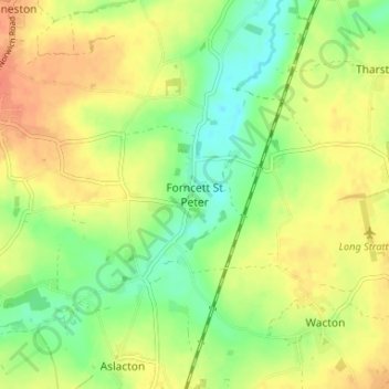
Forncett St Peter topographic map
Interactive map
Click on the map to display elevation.
About this map
Name: Forncett St Peter topographic map, elevation, terrain.
Average elevation: 43 m
Minimum elevation: 19 m
Maximum elevation: 66 m
Norfolk trails, hiking, mountain biking, running and outdoor activities
Other topographic maps
Click on a map to view its topography, its elevation and its terrain.
Ketteringham
United Kingdom > England > Norfolk > South Norfolk > Ketteringham
Average elevation: 41 m
East Carleton
United Kingdom > England > Norfolk > South Norfolk > East Carleton
Average elevation: 40 m
Poringland Wood
United Kingdom > England > Norfolk > South Norfolk > Framingham Earl
Average elevation: 50 m
Pulham St. Mary
United Kingdom > England > Norfolk > South Norfolk > Pulham St Mary
Average elevation: 45 m
Wymondham
United Kingdom > England > Norfolk > South Norfolk
Wymondham's topography is marked by its river meadow and flat, low-lying agricultural landscape, much like the rest of East Anglia. The parish has an area of 17.11 square miles (44.31 km2). The geology is based on chalk, with a layer of boulder clay laid down in the last ice age. The River Tiffey, flowing…
Average elevation: 43 m
Ashby St. Mary
United Kingdom > England > Norfolk > South Norfolk
Ashby's topography is, like most of East Anglia, made up of river meadows and flat agricultural landscape. The geology mostly consists of Cainozoic Sedimentary rock, with a layer of boulder clay and sand laid down in the last ice age. Ashby St Mary has slightly acidic loamy and clayey soils with impeded…
Average elevation: 20 m
Ashwellthorpe and Fundenhall
United Kingdom > England > Norfolk > South Norfolk
Average elevation: 53 m