
Make a donation
Gear up for your next adventure:
As an Amazon Associate, this site earns from qualifying purchases at no extra cost to you.
Hayden Valley topographic map
Click on the map to display elevation.
Make a donation
Gear up for your next adventure:
As an Amazon Associate, this site earns from qualifying purchases at no extra cost to you.
About this map
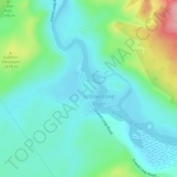
Name: Hayden Valley topographic map, elevation, terrain.
Location: Hayden Valley, Park County, Wyoming, United States (44.63362 -110.46622 44.65362 -110.44622)
Average elevation: 2,373 m
Minimum elevation: 2,339 m
Maximum elevation: 2,481 m
Make a donation
Gear up for your next adventure:
As an Amazon Associate, this site earns from qualifying purchases at no extra cost to you.
Other topographic maps
Click on a map to view its topography, its elevation and its terrain.
Midwest
United States > Wyoming > Natrona County
The town of Midwest, located in Natrona County, Wyoming, sits in a relatively flat, semi-arid landscape characterized by the rolling hills and gentle slopes typical of the Great Plains region. The area's topography is largely defined by expansive grasslands and isolated buttes. Midwest is positioned near…
Average elevation: 1,482 m
Yellowstone National Park
Yellowstone National Park's topography is characterized by a remarkable diversity of geological features shaped by its unique volcanic history and tectonic activity. The park is predominantly situated on the Yellowstone Plateau, which is part of the larger Rocky Mountain range, with elevations ranging from…
Average elevation: 2,450 m
Make a donation
Gear up for your next adventure:
As an Amazon Associate, this site earns from qualifying purchases at no extra cost to you.
Cheyenne
United States > Wyoming > Laramie County
The Cheyenne Regional Airport was opened in 1920, initially serving as a stop for airmail. It soon developed into a civil-military airport, serving DC-3s and various military craft. During World War II, hundreds of B-17s, B-24s, and PBYs were outfitted and upgraded at the airfield. Today, it serves a number of…
Average elevation: 1,871 m
Yellowstone National Park
Yellowstone National Park spans an area of 3,468.4 sq mi (8,983 km2), comprising lakes, canyons, rivers, and mountain ranges. Yellowstone Lake is one of the largest high-elevation lakes in North America and is centered over the Yellowstone Caldera, the largest supervolcano on the continent. The caldera is…
Average elevation: 2,450 m
Grand Teton National Park
United States > Wyoming > Teton County
Grand Teton National Park is named for Grand Teton, the tallest mountain in the Teton Range. The naming of the mountains is attributed to early 19th-century French-speaking trappers—les trois tétons (the three teats) was later anglicized and shortened to Tetons. At 13,775 feet (4,199 m), Grand Teton…
Average elevation: 2,409 m
Laramie
United States > Wyoming > Albany County
Laramie is on a high plain between two mountain ranges, the Snowy Range, about 30 miles (48 km) to the west, and the Laramie Range, 7 miles (11 km) to the east. The city's elevation above sea level is approximately 7,165 feet (2,184 m). The Laramie River runs through Laramie toward its confluence with the…
Average elevation: 2,219 m
Make a donation
Gear up for your next adventure:
As an Amazon Associate, this site earns from qualifying purchases at no extra cost to you.
Grand Teton National Park
United States > Wyoming > Teton County
Grand Teton National Park is named for Grand Teton, the tallest mountain in the Teton Range. The naming of the mountains is attributed to early 19th-century French-speaking trappers—les trois tétons (the three teats) was later anglicized and shortened to Tetons. At 13,775 feet (4,199 m), Grand Teton…
Average elevation: 2,409 m
Make a donation
Gear up for your next adventure:
As an Amazon Associate, this site earns from qualifying purchases at no extra cost to you.
Make a donation
Gear up for your next adventure:
As an Amazon Associate, this site earns from qualifying purchases at no extra cost to you.
Laramie
United States > Wyoming > Albany County
Laramie is on a high plain between two mountain ranges, the Snowy Range, about 30 miles (48 km) to the west, and the Laramie Range, 7 miles (11 km) to the east. The city's elevation above sea level is approximately 7,165 feet (2,184 m). The Laramie River runs through Laramie toward its confluence with the…
Average elevation: 2,219 m
Fremont County
According to the U.S. Census Bureau, the county has a total area of 9,266 square miles (24,000 km2), of which 9,184 square miles (23,790 km2) is land and 82 square miles (210 km2) (0.9%) is water. It is the second-largest county by area in Wyoming, as well as in the six Rocky Mountain States. Elevations and…
Average elevation: 2,108 m
Cody
United States > Wyoming > Park County
Cody's elevation is approximately 5016 ft (1,500 m) above sea level. The main part of the city is split across three levels, separated by about 60 feet (18 m).
Average elevation: 1,557 m
Make a donation
Gear up for your next adventure:
As an Amazon Associate, this site earns from qualifying purchases at no extra cost to you.
Cheyenne
United States > Wyoming > Laramie County
The Cheyenne Regional Airport was opened in 1920, initially serving as a stop for airmail. It soon developed into a civil-military airport, serving DC-3s and various military craft. During World War II, hundreds of B-17s, B-24s, and PBYs were outfitted and upgraded at the airfield. Today, it serves a number of…
Average elevation: 1,871 m
Make a donation
Gear up for your next adventure:
As an Amazon Associate, this site earns from qualifying purchases at no extra cost to you.
Grand Teton National Park
United States > Wyoming > Teton County
Grand Teton National Park is named for Grand Teton, the tallest mountain in the Teton Range. At 13,775 feet (4,199 m), Grand Teton rises more than 7,000 feet (2,100 m) above Jackson Hole. The park has numerous lakes, including 15-mile-long (24 km) Jackson Lake as well as streams and the upper main stem of the…
Average elevation: 2,409 m
Make a donation
Gear up for your next adventure:
As an Amazon Associate, this site earns from qualifying purchases at no extra cost to you.
Jackson
United States > Wyoming > Teton County
Jackson is located at an elevation of 6,237 feet (1,901 m) above sea level. According to the United States Census Bureau, the town has a total area of 3.009 square miles (7.79 km2), of which 2.978 square miles (7.71 km2) is land and 0.031 square miles (0.08 km2) (1.03%) is water.
Average elevation: 2,043 m
Dubois
United States > Wyoming > Fremont County
Dubois is located at 43°32′9″N 109°38′9″W / 43.53583°N 109.63583°W / 43.53583; -109.63583 (43.535936, -109.635915) and an elevation of 2115 m (6940 ft). The Wind River runs through the town.
Average elevation: 2,167 m
Shoshone National Forest
Travels by fur trappers and adventurers, such as Manuel Lisa and Jim Bridger from 1807 to 1840, completed the exploration of the region. With the decline of the fur trade in the late 1840s and much of the prized beaver long since made scarce by over-trapping, few explorers entered the forest over the next few…
Average elevation: 2,183 m
Make a donation
Gear up for your next adventure:
As an Amazon Associate, this site earns from qualifying purchases at no extra cost to you.
Make a donation
Gear up for your next adventure:
As an Amazon Associate, this site earns from qualifying purchases at no extra cost to you.
Fremont County
According to the U.S. Census Bureau, the county has a total area of 9,266 square miles (24,000 km2), of which 9,184 square miles (23,790 km2) is land and 82 square miles (210 km2) (0.9%) is water. It is the second-largest county by area in Wyoming, as well as in the six Rocky Mountain States. Elevations and…
Average elevation: 2,108 m
Make a donation
Gear up for your next adventure:
As an Amazon Associate, this site earns from qualifying purchases at no extra cost to you.
Make a donation
Gear up for your next adventure:
As an Amazon Associate, this site earns from qualifying purchases at no extra cost to you.
Thayne
United States > Wyoming > Lincoln County
Thayne is located at 42°55′11″N 111°0′3″W / 42.91972°N 111.00083°W / 42.91972; -111.00083 (42.919754, –111.000714), at 5906 feet in elevation. It sits in the northern portion of Wyoming's grassy Star Valley, close to the Salt River. Thayne is surrounded by green grassland and ranches,…
Average elevation: 1,814 m
Cheyenne
United States > Wyoming > Laramie County
The Cheyenne Regional Airport was opened in 1920, initially serving as a stop for airmail. It soon developed into a civil-military airport, serving DC-3s and various military craft. During World War II, hundreds of B-17s, B-24s, and PBYs were outfitted and upgraded at the airfield. Today, it serves a number of…
Average elevation: 1,871 m
Make a donation
Gear up for your next adventure:
As an Amazon Associate, this site earns from qualifying purchases at no extra cost to you.
Make a donation
Gear up for your next adventure:
As an Amazon Associate, this site earns from qualifying purchases at no extra cost to you.
Goshen County Fair Grounds
United States > Wyoming > Goshen County > Torrington
Average elevation: 1,258 m
Make a donation
Gear up for your next adventure:
As an Amazon Associate, this site earns from qualifying purchases at no extra cost to you.
Torrington
United States > Wyoming > Goshen County
Torrington is located at 42°4′0″N 104°10′57″W / 42.06667°N 104.18250°W / 42.06667; -104.18250 (42.066542, −104.182471). According to the United States Census Bureau, the city has a total area of 4.62 square miles (11.97 km2), all land. Its elevation is 4,104 feet (1,251 meters).
Average elevation: 1,266 m
Make a donation
Gear up for your next adventure:
As an Amazon Associate, this site earns from qualifying purchases at no extra cost to you.
Laramie
United States > Wyoming > Albany County
Laramie (/ˈlærəmi/) is a city in and the county seat of Albany County, Wyoming, United States, known for its high elevation at 7,200 feet (2,200 m), for its railroad history, and as the home of the University of Wyoming. The population was 31,407 at the 2020 census, making it the fourth-most populous city…
Average elevation: 2,218 m
Make a donation
Gear up for your next adventure:
As an Amazon Associate, this site earns from qualifying purchases at no extra cost to you.
Cody
United States > Wyoming > Park County
Cody's elevation is approximately 5016 ft (1,500 m) above sea level. The main part of the city is split across three levels, separated by about 60 feet (18 m).
Average elevation: 1,557 m
Make a donation
Gear up for your next adventure:
As an Amazon Associate, this site earns from qualifying purchases at no extra cost to you.
Make a donation
Gear up for your next adventure:
As an Amazon Associate, this site earns from qualifying purchases at no extra cost to you.
Evanston
United States > Wyoming > Uinta County
Evanston is located at 41°16′5.81″N 110°57′47.65″W / 41.2682806°N 110.9632361°W / 41.2682806; -110.9632361 (41.2682794, -110.9632373). The elevation is 6,749 feet (2,057 m) above sea level.
Average elevation: 2,100 m
Make a donation
Gear up for your next adventure:
As an Amazon Associate, this site earns from qualifying purchases at no extra cost to you.
Make a donation
Gear up for your next adventure:
As an Amazon Associate, this site earns from qualifying purchases at no extra cost to you.
Laramie
United States > Wyoming > Albany County
Laramie (/ˈlærəmi/) is a city in and the county seat of Albany County, Wyoming, United States, known for its high elevation at 7,200 feet (2,200 m), railroad history, and is the home of the University of Wyoming. The population was 31,407 at the 2020 census, making it the fourth-most populous city in…
Average elevation: 2,218 m
Make a donation
Gear up for your next adventure:
As an Amazon Associate, this site earns from qualifying purchases at no extra cost to you.
Fremont County
According to the U.S. Census Bureau, the county has a total area of 9,266 square miles (24,000 km2), of which 9,184 square miles (23,790 km2) is land and 82 square miles (210 km2) (0.9%) is water. It is the second-largest county by area in Wyoming, as well as in the six Rocky Mountain States. Elevations and…
Average elevation: 2,108 m
Make a donation
Gear up for your next adventure:
As an Amazon Associate, this site earns from qualifying purchases at no extra cost to you.
Make a donation
Gear up for your next adventure:
As an Amazon Associate, this site earns from qualifying purchases at no extra cost to you.
Worland
United States > Wyoming > Washakie County
Due to the location within the Big Horn Basin, it is protected from severe weather by the surrounding mountains from nearly every direction. This topography results in weather that is highly continental with frigid and dry winters, little wind, little rainfall and few storms. Worland is the least windy…
Average elevation: 1,268 m
Make a donation
Gear up for your next adventure:
As an Amazon Associate, this site earns from qualifying purchases at no extra cost to you.