
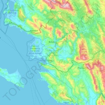
Thesprotia Regional Unit topographic map
Interactive map
Click on the map to display elevation.
About this map
Name: Thesprotia Regional Unit topographic map, elevation, terrain.
Average elevation: 274 m
Minimum elevation: -7 m
Maximum elevation: 1,792 m
Other topographic maps
Click on a map to view its topography, its elevation and its terrain.
Gramos
Greece > Epirus and Western Macedonia > Kastoria Regional Unit > Gramos Municipal Unit
Average elevation: 1,609 m
Mazi
Greece > Epirus and Western Macedonia > Florina Regional Unit > Prespes Municipal Unit
Average elevation: 1,423 m
Melissovouno
Greece > Epirus and Western Macedonia > Florina Regional Unit > Meliti Municipal Unit > Σιταριά
Average elevation: 634 m
Samarina
Greece > Epirus and Western Macedonia > Grevena Regional Unit
Samarina is located on an eastern spur of Mount Smolikas, the highest of the Pindus range and the second-highest mountain in all of Greece. At an altitude of 1380–1515 meters (4528' to 4970'), it is considered one of the highest villages in Greece and also one of the highest in the Balkans; its height puts…
Average elevation: 1,558 m
Δεσκάτη
Greece > Epirus and Western Macedonia > Grevena Regional Unit > Deskati Municipal Unit
Average elevation: 952 m
Μικρό Πάπιγκο
Greece > Epirus and Western Macedonia > Ioannina Regional Unit
Average elevation: 1,237 m
Arillas
Greece > Epirus and Western Macedonia > Thesprotia Regional Unit > Perdika
Average elevation: 94 m
Ζαπάτιστα
Greece > Epirus and Western Macedonia > Kozani Regional Unit > Πεντάλοφος
Average elevation: 1,085 m
Prodromi
Greece > Epirus and Western Macedonia > Thesprotia Regional Unit > Prodromi
Average elevation: 316 m
Φιλιάτες
Greece > Epirus and Western Macedonia > Thesprotia Regional Unit > Φιλιάτες
Average elevation: 253 m
Βραδέτο
Greece > Epirus and Western Macedonia > Ioannina Regional Unit > Καπέσοβο > Βραδέτο
Average elevation: 1,174 m
Neraida
Greece > Epirus and Western Macedonia > Thesprotia Regional Unit > Neraida
Average elevation: 197 m