
Kensington topographic map
Interactive map
Click on the map to display elevation.
About this map
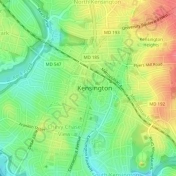
Name: Kensington topographic map, elevation, terrain.
Average elevation: 95 m
Minimum elevation: 66 m
Maximum elevation: 135 m
Other topographic maps
Click on a map to view its topography, its elevation and its terrain.
Upper Long Branch Neighborhood Park
United States > Maryland > Montgomery County > Four Corners
Average elevation: 87 m
Hungerford Towne
United States > Maryland > Montgomery County > Rockville > Hungerford Towne
Average elevation: 122 m
Clearspring Manor
United States > Maryland > Montgomery County > Damascus > Clearspring Manor
Average elevation: 215 m