Geolocate

Cherry Valley topographic map

Click on the map to display elevation.

About this map

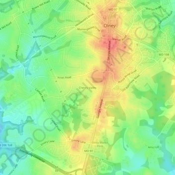
Name: Cherry Valley topographic map, elevation, terrain.

Location: Cherry Valley, Olney, Montgomery County, Maryland, 20832, United States (39.11900 -77.09331 39.15900 -77.05331)

Average elevation: 141 m

Minimum elevation: 112 m

Maximum elevation: 175 m

Other topographic maps

Click on a map to view its topography, its elevation and its terrain.

Olney

United States > Maryland > Montgomery County > Olney

Average elevation: 136 m

Olney

United States > Maryland > Montgomery County > Olney

Average elevation: 136 m

Olney

United States > Maryland > Montgomery County > Olney

Average elevation: 136 m

Gear up for your next adventure:

🩹Hiking First Aid Kits - Compact medical kits tailored for trail injuries and emergencies
📢Survival Whistles - Essential safety gear for signaling for help in mountain fog
🎒Multi-day Trekking Packs - Large capacity backpacks for wild camping and long-distance trails
🧺Ultralight Dry Bags - Organize and waterproof your gear inside your rucksack
🧼Camping Hygiene Kits - Compact hygiene essentials for outdoor stays

As an Amazon Associate, this site earns from qualifying purchases at no extra cost to you.