
Olney topographic map
Click on the map to display elevation.
About this map
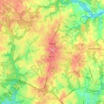
Name: Olney topographic map, elevation, terrain.
Location: Olney, Montgomery County, Maryland, United States (39.10895 -77.11047 39.18515 -77.02751)
Average elevation: 136 m
Minimum elevation: 90 m
Maximum elevation: 175 m
Other topographic maps
Click on a map to view its topography, its elevation and its terrain.
Carroll Knolls Park
United States > Maryland > Montgomery County > Silver Spring > Plyers Mill Estates
Average elevation: 111 m
Damascus
United States > Maryland > Montgomery County
As an unincorporated area, Damascus' boundaries are not officially defined. Damascus is recognized by the United States Census Bureau as a census-designated place, and by the United States Geological Survey as a populated place located at 39°16′16″N 77°12′22″W / 39.27111°N 77.20611°W /…
Average elevation: 204 m
Damascus
United States > Maryland > Montgomery County
As an unincorporated area, Damascus' boundaries are not officially defined. Damascus is recognized by the United States Census Bureau as a census-designated place, and by the United States Geological Survey as a populated place located. Damascus proper is a locally high spot at 847 ft (258m) above sea level,…
Average elevation: 204 m
Upper Long Branch Neighborhood Park
United States > Maryland > Montgomery County > Four Corners
Average elevation: 87 m
Clearspring Manor
United States > Maryland > Montgomery County > Damascus > Clearspring Manor
Average elevation: 215 m
Hungerford Towne
United States > Maryland > Montgomery County > Rockville > Hungerford Towne
Average elevation: 122 m