
Rock Creek topographic map
Interactive map
Click on the map to display elevation.
About this map
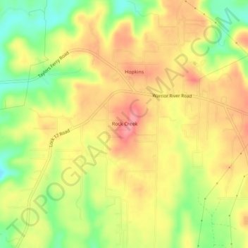
Name: Rock Creek topographic map, elevation, terrain.
Location: Rock Creek, Jefferson County, Alabama, United States (33.45911 -87.09820 33.49486 -87.06435)
Average elevation: 148 m
Minimum elevation: 95 m
Maximum elevation: 188 m
Other topographic maps
Click on a map to view its topography, its elevation and its terrain.
Birmingham
United States > Alabama > Jefferson County
Birmingham has a varied and rugged topography shaped by the nearby Appalachian foothills. The city sits at an average elevation of around 600 feet (183 meters), though it is surrounded by more dramatic terrain that rises higher to 1,000 feet (305 meters) in some areas, particularly to the south and east.…
Average elevation: 193 m
Mobile
United States > Alabama > Mobile County
According to the United States Census Bureau, the city has a total area of 180.1 square miles (466 km2), with 139.5 square miles (361 km2) of it being land, and 40.6 square miles (105.2 km2), or 22.5% of the total, being covered by water. The elevation in Mobile ranges from 10 feet (3 m) on Water Street in…
Average elevation: 16 m
Daphne
United States > Alabama > Baldwin County
The topography of Daphne is quite consistent from a gently sloping sea level on the west to low rolling hills further east. Generally, the entire city lies no more than 150 feet above sea level. The land along the Daphne bay coast, like other land throughout the county, is rich with sandy-loam type soils.
Average elevation: 25 m
Mobile
United States > Alabama > Mobile County
According to the United States Census Bureau, the city has a total area of 180.1 square miles (466 km2), with 139.5 square miles (361 km2) of it being land, and 40.6 square miles (105.2 km2), or 22.5% of the total, being covered by water. The elevation in Mobile ranges from 10 feet (3 m) on Water Street in…
Average elevation: 16 m
Madison County
The topography in the southern and eastern portions of the county is dominated by the dissected remnants of the Cumberland Plateau, such as Keel Mountain, Monte Sano Mountain and Green Mountain. The northern and western portions of the county are flatter.
Average elevation: 245 m
Tuscaloosa
United States > Alabama > Tuscaloosa County
The Tuscaloosa National Airport (KTCL) is 3.5 miles northwest of Tuscaloosa in Tuscaloosa County, Alabama. Owned and operated by the City of Tuscaloosa, the airport is an FAA-designated National General Aviation Airport and Part 139 Certified. Tuscaloosa National Airport covers 826 acres at an elevation of…
Average elevation: 97 m
Dothan
United States > Alabama > Houston County
It is located in the Wiregrass region of southeastern Alabama, near both the Florida and Georgia state lines. The topography is generally flat and forested, with few small hills that gradually slope downward towards the Chattahoochee River to the east and the gulf coastal plain to the south.
Average elevation: 88 m
Mobile
United States > Alabama > Mobile County
According to the United States Census Bureau, the city has a total area of 180.1 square miles (466 km2), with 139.5 square miles (361 km2) of it being land, and 40.6 square miles (105.2 km2), or 22.5% of the total, being covered by water. The elevation in Mobile ranges from 10 feet (3 m) on Water Street in…
Average elevation: 16 m
Jefferson County
Jefferson County showcases a varied and dynamic topography characterized by its location within the Ridge-and-Valley Appalachian region. The county's terrain features rolling hills and valleys, which rise and fall gently across its landscape. The average elevation in the county hovers around 568 feet, with…
Average elevation: 173 m
Greater Washington Park
United States > Alabama > Montgomery County > Montgomery
Average elevation: 53 m
Cheaha Mountain
United States > Alabama > Cleburne County
Cheaha Mountain is part of the Talladega Mountains, a small section of the Ridge and Valley Mountains, unlike other elevations of the Appalachians in north Alabama, which are part of the Cumberland Plateau. The mountain is the highest point in the eastern portion of the Sun Belt (east of the Mississippi River,…
Average elevation: 543 m
Albertville
United States > Alabama > Marshall County
The city sits at an elevation of 1,060 feet (320 m) atop Sand Mountain, a plateau that in this area is about 15 miles (24 km) wide. The Tennessee Valley Divide passes through the southern part of the city. The majority of the city drains north to Short Creek, a tributary of the Tennessee River, while the…
Average elevation: 309 m
Auburn
United States > Alabama > Lee County
The southwest and west regions of the city on the plateau are marked by rolling plains and savannahs, with the undeveloped portion primarily being used for cattle grazing and ranching. South of this region sits the coastal plain, with sandy soil and pine forest. Parts of north Auburn have much more rugged…
Average elevation: 200 m
Crestline Heights
United States > Alabama > Jefferson County > Mountain Brook
Average elevation: 241 m
Harvest
United States > Alabama > Madison County > Harvest
Capshaw Mountain (1,250 feet above sea level) is the only notable geological feature in the area, which extends about 800 feet above the general elevation in the area. The top of this small mountain is the site of several substantial communications towers used by local radio stations. Capshaw Mountain forms a…
Average elevation: 254 m
Auburn
United States > Alabama > Lee County
The southwest and west regions of the city on the plateau are marked by rolling plains and savannahs, with the undeveloped portion primarily being used for cattle grazing and ranching. South of this region sits the coastal plain, with sandy soil and pine forest. Parts of north Auburn have much more rugged…
Average elevation: 200 m