Geolocate

Greenville topographic map

Interactive map

Click on the map to display elevation.

About this map

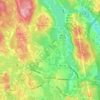
Name: Greenville topographic map, elevation, terrain.

Location: Greenville, Providence County, Rhode Island, 02828, United States (41.85860 -71.58029 41.91480 -71.53072)

Average elevation: 97 m

Minimum elevation: 38 m

Maximum elevation: 165 m

Other topographic maps

Click on a map to view its topography, its elevation and its terrain.

Smithfield

United States > Rhode Island > Providence County

Smithfield, Providence County, Rhode Island, United States

Average elevation: 107 m

Scituate

United States > Rhode Island > Providence County

Scituate, Providence County, Rhode Island, United States

Average elevation: 124 m

East Providence

United States > Rhode Island > Providence County

East Providence, Providence County, Rhode Island, United States

Average elevation: 12 m

Johnston

United States > Rhode Island > Providence County

Johnston, Providence County, Rhode Island, 02919, United States

Average elevation: 97 m

Ashton

United States > Rhode Island > Providence County > Cumberland

Ashton, Cumberland, Providence County, Rhode Island, 02864, United States

Average elevation: 60 m

Pawtucket

United States > Rhode Island > Providence County

Pawtucket, Providence County, Rhode Island, United States

Average elevation: 24 m

Durfee Hill

United States > Rhode Island > Providence County > Glocester

Durfee Hill, Glocester, Providence County, Rhode Island, United States

Average elevation: 211 m

Conservation Land (Trails)

United States > Rhode Island > Providence County > Cumberland

Conservation Land (Trails), Lippitt Estate, Cumberland, Providence County, Rhode Island, United States

Average elevation: 73 m

Seekonk River

United States > Rhode Island > Providence County

Seekonk River, Pawtucket, Providence County, Rhode Island, 02860, United States

Average elevation: 21 m

Olneyville

United States > Rhode Island > Providence County > Providence > Olneyville

Olneyville, Providence, Providence County, Rhode Island, 02909, United States

Average elevation: 24 m

Providence

United States > Rhode Island > Providence County

Providence, Providence County, Rhode Island, United States

Average elevation: 19 m

Foster

United States > Rhode Island > Providence County

Foster, Providence County, Rhode Island, 02825, United States

Average elevation: 171 m

Pascoag

United States > Rhode Island > Providence County > Burrillville > Pascoag

Pascoag, Burrillville, Providence County, Rhode Island, 02859, United States

Average elevation: 141 m

Glocester

United States > Rhode Island > Providence County

Glocester, Providence County, Rhode Island, United States

Average elevation: 166 m

Cranston

United States > Rhode Island > Providence County

Cranston, Providence County, Rhode Island, United States

Average elevation: 27 m

Woonsocket

United States > Rhode Island > Providence County

Woonsocket, Providence County, Rhode Island, 02895, United States

Average elevation: 74 m