
Columbus topographic map
Interactive map
Click on the map to display elevation.
About this map
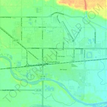
Name: Columbus topographic map, elevation, terrain.
Location: Columbus, Platte County, Nebraska, United States (41.40238 -97.39830 41.46771 -97.29998)
Average elevation: 442 m
Minimum elevation: 431 m
Maximum elevation: 469 m
The city lies at an elevation of 1,447 feet (441 m). It is built on the flat terrain of the Platte River valley; rolling hills rise to the north of the city.
Other topographic maps
Click on a map to view its topography, its elevation and its terrain.
Carriage House Estates
United States > Nebraska > Platte County > Columbus
Carriage House Estates, Columbus, Platte County, Nebraska, 68601, United States
Average elevation: 440 m