
Göteborgs Stad topographic map
Interactive map
Click on the map to display elevation.
About this map
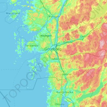
Name: Göteborgs Stad topographic map, elevation, terrain.
Location: Göteborgs Stad, Västra Götaland County, Sweden (57.49966 11.23156 57.86596 12.24183)
Average elevation: 44 m
Minimum elevation: -3 m
Maximum elevation: 213 m
Other topographic maps
Click on a map to view its topography, its elevation and its terrain.
Skövde
Sweden > Västra Götaland County
Skövde has a maritime-continental hybrid climate. The town is influenced by being in the slope of a hill, which leads to warmer overnight lows than in Skara on the western side of the same higher area. In July 2018, Skövde recorded a 22 °C (72 °F) mean during the 2018 European heat wave. This makes it one…
Average elevation: 181 m