
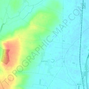
Bathley CP topographic map
Interactive map
Click on the map to display elevation.
About this map
Name: Bathley CP topographic map, elevation, terrain.
Average elevation: 23 m
Minimum elevation: 8 m
Maximum elevation: 64 m
Nottinghamshire trails, hiking, mountain biking, running and outdoor activities
Other topographic maps
Click on a map to view its topography, its elevation and its terrain.
Newark on Trent
United Kingdom > England > Nottinghamshire > Newark and Sherwood
Average elevation: 18 m
Goverton
United Kingdom > England > Nottinghamshire > Newark and Sherwood > Bleasby
Average elevation: 34 m
Sherwood Forest NNR
United Kingdom > England > Nottinghamshire > Newark and Sherwood > Ollerton > Edwinstowe CP
Average elevation: 71 m
Blidworth Bottoms
United Kingdom > England > Nottinghamshire > Newark and Sherwood > Blidworth CP
Average elevation: 107 m
Farndon
United Kingdom > England > Nottinghamshire > Newark and Sherwood > Farndon
Average elevation: 14 m
Kings Clipstone
United Kingdom > England > Nottinghamshire > Newark and Sherwood
Average elevation: 81 m
Danethorpe Hill
United Kingdom > England > Nottinghamshire > Newark and Sherwood
Average elevation: 22 m