
Millstone Township topographic map
Interactive map
Click on the map to display elevation.
About this map
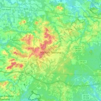
Name: Millstone Township topographic map, elevation, terrain.
Average elevation: 49 m
Minimum elevation: 24 m
Maximum elevation: 104 m
Other topographic maps
Click on a map to view its topography, its elevation and its terrain.
Hendrickson Corners
United States > New Jersey > Monmouth County > Middletown Township
Average elevation: 22 m
Emleys Hill
United States > New Jersey > Monmouth County > Upper Freehold Township
Average elevation: 46 m
Hendrickson Corners
United States > New Jersey > Monmouth County > Middletown Township
Average elevation: 22 m
Burlington Heights
United States > New Jersey > Monmouth County > Freehold Township
Average elevation: 47 m
Hendrickson Corners
United States > New Jersey > Monmouth County > Middletown Township
Average elevation: 22 m
New Monmouth
United States > New Jersey > Monmouth County > Middletown Township
Average elevation: 15 m
Freehold
United States > New Jersey > Monmouth County > Freehold Borough > Freehold
Freehold has an elevation of 174 feet (53 m) above sea level at its center.
Average elevation: 45 m
Carrs Tavern
United States > New Jersey > Monmouth County > Millstone Township > Carrs Tavern
Average elevation: 53 m
Collingwood Park
United States > New Jersey > Monmouth County > Collingwood Park
Average elevation: 31 m
Bradley Park
United States > New Jersey > Monmouth County > Neptune > Bradley Park
Average elevation: 7 m
Port-au-Peck
United States > New Jersey > Monmouth County > Oceanport > Port-au-Peck
Average elevation: 4 m