
Atiu topographic map
Interactive map
Click on the map to display elevation.
About this map
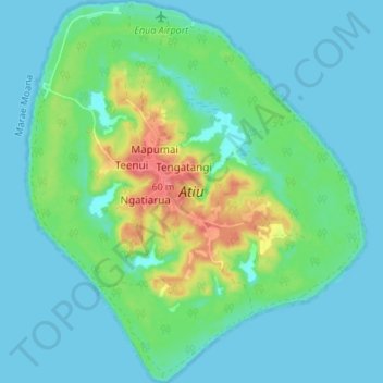
Name: Atiu topographic map, elevation, terrain.
Location: Atiu, Cook Islands (-20.02899 -158.14217 -19.96539 -158.08223)
Average elevation: 18 m
Minimum elevation: 0 m
Maximum elevation: 81 m
Other topographic maps
Click on a map to view its topography, its elevation and its terrain.
Lake Tiriroto
Cook Islands > Atiu > Ngatiarua
Lake Tiriroto, Ngatiarua, Atiu, Cook Islands
Average elevation: 29 m