
Make a donation
Gear up for your next adventure:
As an Amazon Associate, this site earns from qualifying purchases at no extra cost to you.
Indian John Island topographic map
Click on the map to display elevation.
Make a donation
Gear up for your next adventure:
As an Amazon Associate, this site earns from qualifying purchases at no extra cost to you.
About this map
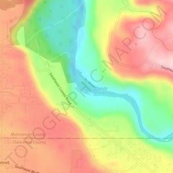
Name: Indian John Island topographic map, elevation, terrain.
Location: Indian John Island, Multnomah, Oregon, United States (45.46866 -122.28897 45.47031 -122.28402)
Average elevation: 156 m
Minimum elevation: 30 m
Maximum elevation: 268 m
Make a donation
Gear up for your next adventure:
As an Amazon Associate, this site earns from qualifying purchases at no extra cost to you.
Other topographic maps
Click on a map to view its topography, its elevation and its terrain.
Portland
United States > Oregon > Multnomah County
Portland features a striking and varied topography characterized by its location at the confluence of the Willamette and Columbia Rivers. The city lies within the fertile Willamette Valley, flanked by the snow-capped Cascade Mountains to the east, including the prominent Mount Hood, and the less elevated…
Average elevation: 77 m
Salem
United States > Oregon > Marion County
Salem is situated in the heart of the Willamette Valley and features a varied topography shaped by its proximity to notable geological formations. The city itself is primarily located at an elevation of around 177 feet (54 meters), but it spans a range from approximately 120 to 800 feet (37 to 244 meters)…
Average elevation: 96 m
Eugene
United States > Oregon > Lane County
Eugene is characterized by a varied topography that contributes to its picturesque landscapes. The city sits at an average elevation of about 426 feet (130 meters) and is nestled within the Willamette Valley, surrounded by the foothills of the Cascade Mountains to the east, which rise significantly in…
Average elevation: 163 m
Bend
United States > Oregon > Deschutes County
Bend is characterized by its distinctive topography, situated at an elevation of approximately 3,623 feet (1,105 meters) above sea level. The city lies within the high desert region of Central Oregon, bordered by the Cascade Mountains to the west, which provide a dramatic backdrop with peaks like the Three…
Average elevation: 1,121 m
Make a donation
Gear up for your next adventure:
As an Amazon Associate, this site earns from qualifying purchases at no extra cost to you.
Make a donation
Gear up for your next adventure:
As an Amazon Associate, this site earns from qualifying purchases at no extra cost to you.
Portland
United States > Oregon > Multnomah County
Annual snowfall in Portland is 4.3 inches (10.9 cm), which usually falls between December and March. The city of Portland avoids snow more frequently than its suburbs, due in part to its low elevation and the urban heat island effect. Neighborhoods outside of the downtown core, especially in slightly higher…
Average elevation: 77 m
Klamath Falls
United States > Oregon > Klamath County
Klamath Falls, located at an elevation of approximately 4,108 feet, is situated in a striking topographical region characterized by a mix of mountainous terrains and expansive lakes. The city is bordered by the Klamath Mountains to the west, which feature rugged, volcanic formations and steep slopes that…
Average elevation: 1,312 m
Ashland
United States > Oregon > Jackson County
Ashland lies within Oregon's southwest interior climate zone, in which all but the higher-elevation sites are in the rain shadow of the Oregon Coast Range to the west. The largest urban areas in this zone in addition to Ashland are Medford and Grants Pass in the Rogue Valley, and Roseburg in the Umpqua River…
Average elevation: 774 m
Make a donation
Gear up for your next adventure:
As an Amazon Associate, this site earns from qualifying purchases at no extra cost to you.
Beaverton
United States > Oregon > Washington County
As of January 2020, Beaverton covers a total area of 19.7 square miles (51 km2), all of it land except for small creeks, ponds, and lakes. The city is located along the eastern edge of the Tualatin Valley just west of the Tualatin Mountains. It is bordered by Portland to the east, Hillsboro to the west, and…
Average elevation: 106 m
Mount Hood
United States > Oregon > Hood River County
Timberline Lodge is a National Historic Landmark located on the southern flank of Mount Hood just below Palmer Glacier, with an elevation of about 6,000 ft (1,800 m).
Average elevation: 2,716 m
Hillsboro
United States > Oregon > Washington County
Hillsboro is located at 45°31′N 122°59′W / 45.517°N 122.983°W / 45.517; -122.983 (Hillsboro, Oregon). The United States Census Bureau reports the city has a total area of 21.6 square miles (55.9 km2), all of which is land. In 2013, Hillsboro itself reported an area of 23.88 square miles…
Average elevation: 53 m
Make a donation
Gear up for your next adventure:
As an Amazon Associate, this site earns from qualifying purchases at no extra cost to you.
Roseburg
United States > Oregon > Douglas County
Roseburg's elevation is approximately 500 feet (150 m). Its highest point is Mount Nebo, a 1,200-foot (370 m) hill to the west of Interstate 5. Through the 1980s, it was known for its band of 10-20 feral angora goats. Residents said they could predict the weather by watching where the goats were on the…
Average elevation: 239 m
Corvallis
United States > Oregon > Benton County
Corvallis is at an elevation of 235 feet (72 m) above sea level. Situated midway in the Willamette Valley, in terms of driving distances, Corvallis is about 46 miles (74 km) east of Newport and the Oregon Coast, 85 miles (137 km) south of Portland, 30 miles (48 km) south of the state capital, Salem, 10 miles…
Average elevation: 81 m
Black Butte
United States > Oregon > Jefferson County
According to the U.S. National Geodetic Survey and scientists from the United States Geological Survey, Black Butte has an elevation of 6,436 feet (1,962 m); the Geographic Names Information System database lists its elevation as 6,430 feet (1,960 m), while Oregon Geographic Names lists its elevation at 6,415…
Average elevation: 1,514 m
Make a donation
Gear up for your next adventure:
As an Amazon Associate, this site earns from qualifying purchases at no extra cost to you.
Redmond
United States > Oregon > Deschutes County
The city encompasses 15.5 square miles (40 km2) and is on a plateau, at an elevation of 3,077 feet (938 m). Redmond is 15 miles (24 km) north of Bend—the county seat of Deschutes County—144 miles (232 km) from Portland, 129 miles (208 km) from Salem—the capital of Oregon—and 126 miles (203 km) from Eugene.
Average elevation: 923 m
Gresham
United States > Oregon > Multnomah County
Though much of Gresham is relatively flat, it is characterized by a hill on its eastern border. Northeast Gresham is also hilly, particularly where the city meets Troutdale toward the Columbia River. Its elevation is 325 feet (99 m). Johnson Creek, which begins at the foothills of the Cascade Mountains, runs…
Average elevation: 90 m
Make a donation
Gear up for your next adventure:
As an Amazon Associate, this site earns from qualifying purchases at no extra cost to you.
Hood River
United States > Oregon > Hood River County
Temperatures for the year as a whole are slightly cooler than in most other low-elevation towns in the region, especially at night because of air drainage off the surrounding mountains.
Average elevation: 112 m
Make a donation
Gear up for your next adventure:
As an Amazon Associate, this site earns from qualifying purchases at no extra cost to you.
Beaverton
United States > Oregon > Washington County
As of January 2020, Beaverton covers a total area of 19.7 square miles (51 km2), all of it land except for small creeks, ponds, and lakes. The city is located along the eastern edge of the Tualatin Valley just west of the Tualatin Mountains. It is bordered by Portland to the east, Hillsboro to the west, and…
Average elevation: 106 m
Lane County
Lane County showcases a strikingly diverse topography that spans a wide range of elevations and geological features. This area extends from sea level along the picturesque Pacific coastline to the towering peaks of the Cascade Mountains, where elevations exceed 10,000 feet. The western region is characterized…
Average elevation: 712 m
Make a donation
Gear up for your next adventure:
As an Amazon Associate, this site earns from qualifying purchases at no extra cost to you.
Newberg
United States > Oregon > Yamhill County
According to the United States Census Bureau, the city has a total area of 5.81 square miles (15.05 km2), all of it land. It averages 176 feet (54 m) in elevation.
Average elevation: 61 m
Make a donation
Gear up for your next adventure:
As an Amazon Associate, this site earns from qualifying purchases at no extra cost to you.
Coos Bay
United States > Oregon > Coos County
According to the United States Census Bureau, the city has a total area of 15.90 square miles (41.18 km2), of which, 10.60 square miles (27.45 km2) is land and 5.30 square miles (13.73 km2) is water. The city is quite hilly, with elevations ranging from between sea level to over 500 feet (150 m). Bodies of…
Average elevation: 30 m
Tillamook County
According to the United States Census Bureau, the county has a total area of 1,333 square miles (3,450 km2), of which 1,103 square miles (2,860 km2) is land and 230 square miles (600 km2) (17%) is water. At 3,706 feet (1130 m) in elevation, Rogers Peak is the highest point in the county and the highest in the…
Average elevation: 236 m
Make a donation
Gear up for your next adventure:
As an Amazon Associate, this site earns from qualifying purchases at no extra cost to you.
Tillamook County
According to the United States Census Bureau, the county has a total area of 1,333 square miles (3,450 km2), of which 1,103 square miles (2,860 km2) is land and 230 square miles (600 km2) (17%) is water. At 3,706 feet (1,130 m) in elevation, Rogers Peak is the highest point in the county and the highest in the…
Average elevation: 236 m
Make a donation
Gear up for your next adventure:
As an Amazon Associate, this site earns from qualifying purchases at no extra cost to you.
Make a donation
Gear up for your next adventure:
As an Amazon Associate, this site earns from qualifying purchases at no extra cost to you.
Lincoln County
Lincoln County, Oregon, presents a diverse and varied topography shaped by its coastal position and the influence of nearby mountain ranges. The region's terrain is dominated by the rugged Pacific coastline, which includes rocky headlands, sandy beaches, and dramatic cliffs that drop sharply into the ocean.…
Average elevation: 175 m
Albany
United States > Oregon > Linn County
According to the United States Census Bureau, the city has a total area of 17.75 square miles (45.97 km2), of which 17.54 square miles (45.43 km2) is land and 0.21 square miles (0.54 km2) is water. Albany has 21.7 square miles (56 km2) within its urban growth boundary. Throughout the city limits and urban…
Average elevation: 71 m
Silverton
United States > Oregon > Marion County
Silverton's elevation is between 200 and 250 feet (61 and 76 m) above mean sea level with the steep-sided, heavily-wooded Waldo Hills to the south rising an additional 200 feet (61 m). The agricultural richness of the environs is due to massive and repeated floods from prehistoric Lake Missoula in western…
Average elevation: 103 m
Make a donation
Gear up for your next adventure:
As an Amazon Associate, this site earns from qualifying purchases at no extra cost to you.
Mount Hood
United States > Oregon > Hood River County
Mount Hood, also known as Wy'east, is an active stratovolcano in the Cascade Range and is a member of the Cascade Volcanic Arc. It was formed by a subduction zone on the Pacific Coast and rests in the Pacific Northwest region of the United States. It is located about 50 miles (80 km) east-east-southeast of…
Average elevation: 2,716 m
Make a donation
Gear up for your next adventure:
As an Amazon Associate, this site earns from qualifying purchases at no extra cost to you.
Rogue River
The Rogue River begins at Boundary Springs on the border between Klamath and Douglas counties near the northern edge of Crater Lake National Park. Although it changes direction many times, it flows generally west for 215 miles (346 km) from the Cascade Range through the Rogue River–Siskiyou National Forest…
Average elevation: 756 m
Make a donation
Gear up for your next adventure:
As an Amazon Associate, this site earns from qualifying purchases at no extra cost to you.
Cannon Beach
United States > Oregon > Clatsop County
Cannon Beach is recognized by the well-known landmark Haystack Rock, located southwest of downtown Cannon Beach. This sea stack has an elevation of 235 feet (72 m) and is often accessible at low tide, especially in the summertime. There is a small cave system that penetrates its igneous rock that can be seen…
Average elevation: 42 m
Willamette National Forest
The elevation of the forest ranges from about 1,500 feet (460 m) above sea level on the western edge of the forest to almost 10,500 feet (3,200 m) at the top of Mount Jefferson, Oregon's second highest peak. Seven major peaks of the Cascades—Mount Jefferson, Mount Washington, Three Fingered Jack, Diamond…
Average elevation: 1,001 m
Make a donation
Gear up for your next adventure:
As an Amazon Associate, this site earns from qualifying purchases at no extra cost to you.
Eugene
United States > Oregon > Lane County
According to the United States Census Bureau, the city has a total area of 43.74 square miles (113.29 km2), of which 43.72 square miles (113.23 km2) is land and 0.02 square miles (0.05 km2) is water. Eugene is at an elevation of 426 feet (130 m).
Average elevation: 163 m
Make a donation
Gear up for your next adventure:
As an Amazon Associate, this site earns from qualifying purchases at no extra cost to you.
Make a donation
Gear up for your next adventure:
As an Amazon Associate, this site earns from qualifying purchases at no extra cost to you.
Coos Bay
United States > Oregon > Coos County
According to the United States Census Bureau, the city has a total area of 15.90 square miles (41.18 km2), of which, 10.60 square miles (27.45 km2) is land and 5.30 square miles (13.73 km2) is water. The city is quite hilly, with elevations ranging from between sea level to over 500 feet (150 m). Bodies of…
Average elevation: 30 m
Crater Lake National Park
United States > Oregon > Klamath County
The caldera rim ranges in elevation from 7,000 to 8,000 feet (2,100 to 2,400 m). The United States Geological Survey benchmark elevation of the lake surface is 6,178 feet (1,883 m). The national park encompasses 183,224 acres (286.3 sq mi; 741.5 km2). Crater Lake has no streams flowing into or out of it. All…
Average elevation: 1,726 m
Cave Junction
United States > Oregon > Josephine County
Cave Junction is located on U.S. Route 199 at its junction with Oregon Route 46. It is about 30 miles or 48 kilometres southwest of Grants Pass, Oregon, and 53 miles or 85 kilometres northeast of Crescent City, California. The city lies in the Illinois Valley, on the northwest slope of the Siskiyou Range, at…
Average elevation: 411 m
Make a donation
Gear up for your next adventure:
As an Amazon Associate, this site earns from qualifying purchases at no extra cost to you.
Make a donation
Gear up for your next adventure:
As an Amazon Associate, this site earns from qualifying purchases at no extra cost to you.
Portland
United States > Oregon > Multnomah County
Annual snowfall in Portland is 4.3 inches (10.9 cm), which usually falls during the December-to-March time frame. The city of Portland avoids snow more frequently than its suburbs, due in part to its low elevation and urban heat island effect. Neighborhoods outside of the downtown core, especially in slightly…
Average elevation: 77 m
Make a donation
Gear up for your next adventure:
As an Amazon Associate, this site earns from qualifying purchases at no extra cost to you.
Pilot Butte
United States > Oregon > Deschutes County > Bend
The 114.22-acre (46.22-hectare) Pilot Butte State Scenic Viewpoint, presented as a gift to the State of Oregon in 1928, is a Bend icon. Pilot Butte itself is a popular hiking destination with two trails to the summit, each gaining about 490 ft (150 m) in elevation. There is also a 1.8-mile (2.9 km) trail…
Average elevation: 1,112 m
Make a donation
Gear up for your next adventure:
As an Amazon Associate, this site earns from qualifying purchases at no extra cost to you.
Make a donation
Gear up for your next adventure:
As an Amazon Associate, this site earns from qualifying purchases at no extra cost to you.
Coos Bay
United States > Oregon > Coos County
According to the United States Census Bureau, the city has a total area of 15.90 square miles (41.18 km2), of which, 10.60 square miles (27.45 km2) is land and 5.30 square miles (13.73 km2) is water. The city is quite hilly, with elevations ranging from between sea level to over 500 feet (150 m). Bodies of…
Average elevation: 30 m
Make a donation
Gear up for your next adventure:
As an Amazon Associate, this site earns from qualifying purchases at no extra cost to you.
Make a donation
Gear up for your next adventure:
As an Amazon Associate, this site earns from qualifying purchases at no extra cost to you.