
Empire Township topographic map
Interactive map
Click on the map to display elevation.
About this map
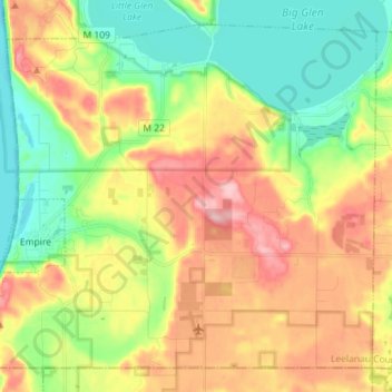
Name: Empire Township topographic map, elevation, terrain.
Location: Empire Township, Leelanau County, Michigan, United States (44.77831 -86.07863 44.86737 -85.93555)
Average elevation: 244 m
Minimum elevation: 170 m
Maximum elevation: 342 m
Other topographic maps
Click on a map to view its topography, its elevation and its terrain.
Lake Leelanau
United States > Michigan > Leelanau County
Lake Leelanau, Leland Township, Leelanau County, Michigan, 49653, United States
Average elevation: 210 m
Northport
United States > Michigan > Leelanau County
Northport, Leelanau Township, Leelanau County, Michigan, 49670, United States
Average elevation: 193 m
Suttons Bay Township
United States > Michigan > Leelanau County
Suttons Bay Township, Leelanau County, Michigan, United States
Average elevation: 221 m
Glen Arbor
United States > Michigan > Leelanau County
Glen Arbor, Glen Arbor Township, Leelanau County, Michigan, 49636, United States
Average elevation: 194 m
Sleeping Bear Dunes National Lakeshore
United States > Michigan > Leelanau County
Sleeping Bear Dunes National Lakeshore, Leelanau County, Michigan, 49636, United States
Average elevation: 204 m
Sleeping Bear Dunes
United States > Michigan > Leelanau County
Sleeping Bear Dunes, Glen Arbor Township, Leelanau County, Michigan, United States
Average elevation: 231 m