
Make a donation
Gear up for your next adventure:
As an Amazon Associate, this site earns from qualifying purchases at no extra cost to you.
Gudauri topographic map
Click on the map to display elevation.
Gear up for your next adventure:
As an Amazon Associate, this site earns from qualifying purchases at no extra cost to you.
Gudauri
Gudauri (Georgian: გუდაური) is a ski resort located on the south-facing plateau of The Greater Caucasus Mountain Range in Georgia. The resort is situated in the Stepantsminda District, along the Georgian Military Highway near the Jvari Pass, at an elevation of 2,200 meters (7,200 ft.) above sea level. Gudauri lies 120 km (75 mi) to the north of the Georgian capital Tbilisi. The resort offers high quality skiing opportunities. The slopes of Gudauri are above the tree line and considered to be avalanche-safe. The ski season lasts from December to April. Heliskiing is available throughout the season.
Make a donation
Gear up for your next adventure:
As an Amazon Associate, this site earns from qualifying purchases at no extra cost to you.
About this map
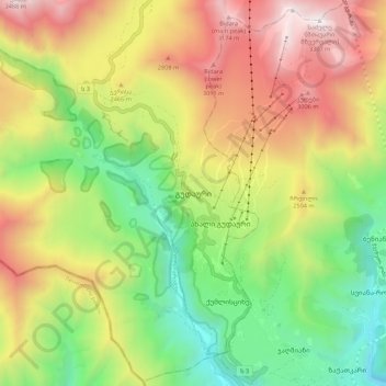
Name: Gudauri topographic map, elevation, terrain.
Average elevation: 2,161 m
Minimum elevation: 1,591 m
Maximum elevation: 2,849 m
Make a donation
Gear up for your next adventure:
As an Amazon Associate, this site earns from qualifying purchases at no extra cost to you.
Other topographic maps
Click on a map to view its topography, its elevation and its terrain.
Stepantsminda
Georgia > Mtskheta-Mtianeti > Kazbegi Municipality
The town is located along the banks of the Terek River, 157 kilometers (98 mi) to the north of Tbilisi at an elevation of 1,740 meters (5,710 feet) above sea level. Stepantsminda’s climate is moderately humid with relatively dry, cold winters and long and cool summers. The average annual temperature is 4.9…
Average elevation: 1,851 m
Gergeti Glacier
Georgia > Mtskheta-Mtianeti > Kazbegi Municipality
Gergeti (Georgian: გერგეთი; also known as Ortsveri) is a glacier located on the southeastern slope of Mt. Kazbek in the Kazbegi District of Georgia. The length of the Gergeti glacier is 7.1 km (4.4 mi) and its surface area is 11 km2 (4.2 sq mi). The tongue of Gergeti descends to 2,900 metres…
Average elevation: 4,009 m
Make a donation
Gear up for your next adventure:
As an Amazon Associate, this site earns from qualifying purchases at no extra cost to you.
Stepantsminda
Georgia > Mtskheta-Mtianeti > Kazbegi Municipality
The town is located along the banks of the Terek River, 157 kilometers (98 mi) to the north of Tbilisi at an elevation of 1,740 meters (5,710 feet) above sea level. Stepantsminda’s climate is moderately humid with relatively dry, cold winters and long and cool summers. The average annual temperature is 4.9…
Average elevation: 1,851 m
Make a donation
Gear up for your next adventure:
As an Amazon Associate, this site earns from qualifying purchases at no extra cost to you.