Geolocate

Konin County topographic map

Interactive map

Click on the map to display elevation.

About this map

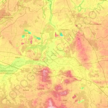
Name: Konin County topographic map, elevation, terrain.

Location: Konin County, Greater Poland Voivodeship, Poland (51.97570 17.93463 52.54347 18.65768)

Average elevation: 104 m

Minimum elevation: 26 m

Maximum elevation: 189 m

Other topographic maps

Click on a map to view its topography, its elevation and its terrain.

Fort IVa

Poland > Greater Poland Voivodeship > Poznań

Average elevation: 71 m

Gliny

Poland > Greater Poland Voivodeship > Konin County

Average elevation: 112 m

Poznań

Poland > Greater Poland Voivodeship > Poznań > Poznań

Average elevation: 86 m

Rudnik

Poland > Greater Poland Voivodeship > Rudnik

Average elevation: 82 m

Jamica

Poland > Greater Poland Voivodeship > Baranów

Average elevation: 171 m

Coch

Poland > Greater Poland Voivodeship > Skrzatusz > Coch

Average elevation: 148 m