
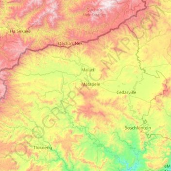
Matatiele Local Municipality topographic map
Interactive map
Click on the map to display elevation.
About this map
Name: Matatiele Local Municipality topographic map, elevation, terrain.
Average elevation: 1,719 m
Minimum elevation: 850 m
Maximum elevation: 3,190 m
Other topographic maps
Click on a map to view its topography, its elevation and its terrain.
Ludeke Dam
South Africa > Eastern Cape > Alfred Nzo District Municipality > Mbizana Local Municipality
Average elevation: 810 m
KwaBhaca (Mount Frere)
South Africa > Eastern Cape > Alfred Nzo District Municipality > Umzimvubu Local Municipality
Average elevation: 1,116 m
eMaXesibeni (Mount Ayliff)
South Africa > Eastern Cape > Alfred Nzo District Municipality > Umzimvubu Local Municipality
Average elevation: 1,128 m
Tabankulu
South Africa > Eastern Cape > Alfred Nzo District Municipality > Ntabankulu Local Municipality
Average elevation: 1,111 m
Mzimvubu
South Africa > Eastern Cape > Alfred Nzo District Municipality > Umzimvubu Local Municipality
Average elevation: 1,041 m
eMaXesibeni (Mount Ayliff)
South Africa > Eastern Cape > Alfred Nzo District Municipality > Umzimvubu Local Municipality
Average elevation: 1,128 m
Bizana
South Africa > Eastern Cape > Alfred Nzo District Municipality > Mbizana Local Municipality
Average elevation: 823 m
eMaXesibeni (Mount Ayliff)
South Africa > Eastern Cape > Alfred Nzo District Municipality > Umzimvubu Local Municipality
Average elevation: 1,128 m
Qwidlana
South Africa > Eastern Cape > Alfred Nzo District Municipality > Umzimvubu Local Municipality
Average elevation: 1,190 m
Ludeke Dam
South Africa > Eastern Cape > Alfred Nzo District Municipality > Mbizana Local Municipality
Average elevation: 810 m
Ntenetyana Dam
South Africa > Eastern Cape > Alfred Nzo District Municipality > Umzimvubu Local Municipality
Average elevation: 1,272 m
Matatiele
South Africa > Eastern Cape > Alfred Nzo District Municipality > Matatiele Local Municipality
Average elevation: 1,603 m
KwaBhaca (Mount Frere)
South Africa > Eastern Cape > Alfred Nzo District Municipality > Umzimvubu Local Municipality
Average elevation: 1,116 m
Bizana
South Africa > Eastern Cape > Alfred Nzo District Municipality > Mbizana Local Municipality
Average elevation: 823 m
eMaXesibeni (Mount Ayliff)
South Africa > Eastern Cape > Alfred Nzo District Municipality > Umzimvubu Local Municipality
Average elevation: 1,128 m
Matatiele
South Africa > Eastern Cape > Alfred Nzo District Municipality > Matatiele Local Municipality
Average elevation: 1,603 m
Matatiele
South Africa > Eastern Cape > Alfred Nzo District Municipality > Matatiele Local Municipality
Average elevation: 1,603 m
Bizana
South Africa > Eastern Cape > Alfred Nzo District Municipality > Mbizana Local Municipality
Average elevation: 823 m