
Jimbolia topographic map
Interactive map
Click on the map to display elevation.
About this map
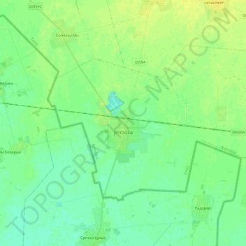
Name: Jimbolia topographic map, elevation, terrain.
Location: Jimbolia, Timiș, 305400, Romania (45.74893 20.65092 45.84548 20.86977)
Average elevation: 80 m
Minimum elevation: 73 m
Maximum elevation: 89 m
Jimbolia is located in the west of Timiș County, 39 km from Timișoara, with which it is connected by the county road 59A and the Kikinda–Jimbolia–Timișoara railway. It lies in the Banat Plain, at the contact between the Timiș Plain and the Mureș Plain. An alignment of villages marks the boundary between the two relief units: Checea–Cărpiniș–Satchinez. The average altitude of the town is 82 m. It is located at the intersection of some roads that connect Romania and Serbia, being also a rail and road border point at the frontier between the two countries.
Other topographic maps
Click on a map to view its topography, its elevation and its terrain.
Teremia Mică
Romania > Timiș > Teremia Mică
Teremia Mică, Timiș, 307407, Romania
Average elevation: 80 m