
Gondola topographic map
Interactive map
Click on the map to display elevation.
About this map
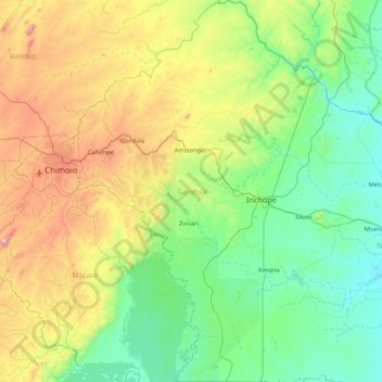
Name: Gondola topographic map, elevation, terrain.
Location: Gondola, Manica Province, Mozambique (-19.59899 33.51327 -18.77984 34.05790)
Average elevation: 338 m
Minimum elevation: 40 m
Maximum elevation: 1,171 m
The climate of the district varies with altitude. The lowlands are characterized by relatively low rainfall, between 800 millimetres (31 in) and 1,100 millimetres (43 in). The transition zone has the average rainfall 1,200 millimetres (47 in), and in higher altitude plains it varies between 1,000 millimetres (39 in) and 1,500 millimetres (59 in).[1]
Other topographic maps
Click on a map to view its topography, its elevation and its terrain.
Inchope
Inchope, Gondola, Manica Province, Mozambique
Average elevation: 208 m
Cidade de Chimoio
Cidade de Chimoio, Manica Province, 2200, Mozambique
Average elevation: 661 m