
Make a donation
Gear up for your next adventure:
As an Amazon Associate, this site earns from qualifying purchases at no extra cost to you.
Engram Branch topographic map
Click on the map to display elevation.
Make a donation
Gear up for your next adventure:
As an Amazon Associate, this site earns from qualifying purchases at no extra cost to you.
About this map
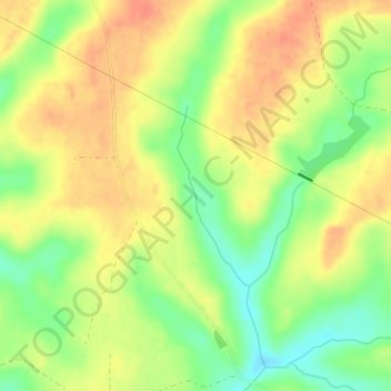
Name: Engram Branch topographic map, elevation, terrain.
Location: Engram Branch, Clay County, Georgia, United States (31.56200 -84.93157 31.57446 -84.92574)
Average elevation: 99 m
Minimum elevation: 72 m
Maximum elevation: 118 m
Make a donation
Gear up for your next adventure:
As an Amazon Associate, this site earns from qualifying purchases at no extra cost to you.
Other topographic maps
Click on a map to view its topography, its elevation and its terrain.
Sky Valley
United States > Georgia > Rabun County
According to the United States Census Bureau, the city has a total area of 3.0 square miles (7.8 km2), all land. The elevation of the valley floor is approximately 3100 feet above sea level, while areas within the city limits on the slopes of Rabun Bald exceed 4200 feet. Sky Valley is Georgia's highest…
Average elevation: 973 m
Atlanta
United States > Georgia > Fulton County
Atlanta features a varied topography characterized by its rolling hills and elevated terrain. The city sits at an average elevation of approximately 1,050 feet (320 meters) above sea level, with elevations ranging from about 725 feet (221 meters) to 1,175 feet (358 meters) in the surrounding areas. This…
Average elevation: 284 m
Atlanta
United States > Georgia > Fulton County
Atlanta (/ætˈlæntə/ at-LAN-tə, or /ætˈlænə/ at-LAN-ə) is the capital and most populous city of the U.S. state of Georgia. It is the seat of Fulton County, although a portion of the city extends into neighboring DeKalb County. With a population of 498,715 living within the city limits, Atlanta is the…
Average elevation: 284 m
Blue Ridge
United States > Georgia > Fannin County
Blue Ridge, situated in Fannin County, Georgia, lies within the rugged terrain of the southern Appalachian Mountains. The town itself is at an elevation of approximately 1,762 feet (537 meters) above sea level. The surrounding landscape is characterized by a series of ridges and valleys, with elevations…
Average elevation: 535 m
Make a donation
Gear up for your next adventure:
As an Amazon Associate, this site earns from qualifying purchases at no extra cost to you.
Savannah
United States > Georgia > Chatham County
Savannah is characterized by a unique and varied topography shaped by its coastal location and historical development. The city is situated on a series of low bluffs along the Savannah River, which flows into the Atlantic Ocean approximately 18 miles (29 km) away. The terrain features a mix of flat coastal…
Average elevation: 4 m
Make a donation
Gear up for your next adventure:
As an Amazon Associate, this site earns from qualifying purchases at no extra cost to you.
Vinings
United States > Georgia > Cobb County
Vinings features a varied topography characterized by rolling hills and lush, wooded areas that provide a picturesque backdrop to the community. The area is nestled alongside the Chattahoochee River, which contributes to the gentle slopes and valleys that define the landscape. Elevations in Vinings typically…
Average elevation: 281 m
Kennesaw
United States > Georgia > Cobb County
Kennesaw is located in northwestern Cobb County, bordered by the city of Acworth to the northwest. Kennesaw Mountain is located southeast of the city limits in the battlefield park. Its summit is the highest point in the Atlanta metro area, at an elevation of 1,808 feet (551 m) above sea level. The city was…
Average elevation: 317 m
Make a donation
Gear up for your next adventure:
As an Amazon Associate, this site earns from qualifying purchases at no extra cost to you.
Peachtree City
United States > Georgia > Fayette County
Shakerag Hill, with an elevation of 980 feet (300 m), is the highest point in the city and sits on the eastern border at the intersection of GA Hwy 54 and Robinson Road.
Average elevation: 262 m
Atlanta
United States > Georgia > Fulton County
Atlanta (/ætˈlæntə/ at-LAN-tə) is the capital and most populous city of the U.S. state of Georgia. It is the seat of Fulton County, the most populous county in Georgia. With a population of 498,715 living within the city limits, it is the eighth most populous city in the Southeast and 38th most populous…
Average elevation: 285 m
Make a donation
Gear up for your next adventure:
As an Amazon Associate, this site earns from qualifying purchases at no extra cost to you.
Rabun County
The Eastern Continental Divide runs through the county, roughly from southwest to northeast, also representing a portion of the Tennessee Valley Divide. The county's eastern border with South Carolina is formed by the Chattooga River, the largest tributary of the Tugaloo River and then Savannah River (which…
Average elevation: 687 m
Atlanta
United States > Georgia > Fulton County
Atlanta (/ætˈlæn(t)ə/ at-LAN-(t)ə) is the capital and most populous city in the U.S. state of Georgia. It is the seat of Fulton County, and a portion of the city extends into neighboring DeKalb County. While not included in city limits, unincorporated areas that carry an Atlanta address spill into…
Average elevation: 284 m
Ellijay
United States > Georgia > Gilmer County
Ellijay sits within a rugged and mountainous terrain, characterized by rolling hills, deep valleys, and ridgelines that are part of the larger Appalachian Mountain system. The area has an average elevation of about 1,390 feet, though nearby peaks like Walnut Mountain rise to elevations over 2,500 feet. The…
Average elevation: 424 m
Make a donation
Gear up for your next adventure:
As an Amazon Associate, this site earns from qualifying purchases at no extra cost to you.
Rabun County
The Eastern Continental Divide runs through the county, roughly from southwest to northeast, also representing a portion of the Tennessee Valley Divide. The county's eastern border with South Carolina is formed by the Chattooga River, the largest tributary of the Tugaloo River and then Savannah River (which…
Average elevation: 687 m
White County
The county is mostly located in the foothills of the Blue Ridge Mountains. Northern parts of the county have the highest elevations, being in the mountains themselves. The highest point in White County is 4,430-foot (1,350 m) Tray Mountain, shared with Towns County to the north. Tray Mountain is the…
Average elevation: 556 m
Make a donation
Gear up for your next adventure:
As an Amazon Associate, this site earns from qualifying purchases at no extra cost to you.
Make a donation
Gear up for your next adventure:
As an Amazon Associate, this site earns from qualifying purchases at no extra cost to you.
Make a donation
Gear up for your next adventure:
As an Amazon Associate, this site earns from qualifying purchases at no extra cost to you.
Dawson County
The county is located in the foothills of the Blue Ridge Mountains. Portions of the mountain chain extend into the far northern and western portions of the county, with elevations around 3,500 ft. in this area.
Average elevation: 462 m
Make a donation
Gear up for your next adventure:
As an Amazon Associate, this site earns from qualifying purchases at no extra cost to you.
Polk County
According to the U.S. Census Bureau, the county has a total area of 312 square miles (810 km2), of which 310 square miles (800 km2) is land and 1.8 square miles (4.7 km2) (0.6%) is water. Much of the county is also covered in rolling hills and small mountains, most of which are part of the Piedmont Plateau and…
Average elevation: 289 m
Stephens County
According to the U.S. Census Bureau, the county has a total area of 184 square miles (480 km2), of which 179 square miles (460 km2) is land and 5.1 square miles (13 km2) (2.8%) is water. The county is located mainly within the upper Piedmont region of the state, with western portions of the county having the…
Average elevation: 299 m
Make a donation
Gear up for your next adventure:
As an Amazon Associate, this site earns from qualifying purchases at no extra cost to you.
Douglas County
Douglas County's elevation above sea level ranges as low as 740 feet (230 m) at the Chattahoochee River to as high as 1,340 feet (410 m); one of the county's highest elevation points lies inside the city of Douglasville. Andy Mountain, between Villa Rica and Winston – west of Douglasville along Bankhead…
Average elevation: 298 m
Make a donation
Gear up for your next adventure:
As an Amazon Associate, this site earns from qualifying purchases at no extra cost to you.
Paulding County
Paulding county is located in the Piedmont region of the Appalachian Mountains, with a few small hills and mountains located in the county that exceed elevations of 1,000 ft. The highest point in Paulding county is an unnamed peak located in Yorkville with an elevation of 1,410 ft (430 m) above sea level. The…
Average elevation: 311 m
Make a donation
Gear up for your next adventure:
As an Amazon Associate, this site earns from qualifying purchases at no extra cost to you.
Make a donation
Gear up for your next adventure:
As an Amazon Associate, this site earns from qualifying purchases at no extra cost to you.
Make a donation
Gear up for your next adventure:
As an Amazon Associate, this site earns from qualifying purchases at no extra cost to you.
Make a donation
Gear up for your next adventure:
As an Amazon Associate, this site earns from qualifying purchases at no extra cost to you.
Make a donation
Gear up for your next adventure:
As an Amazon Associate, this site earns from qualifying purchases at no extra cost to you.
Make a donation
Gear up for your next adventure:
As an Amazon Associate, this site earns from qualifying purchases at no extra cost to you.
Make a donation
Gear up for your next adventure:
As an Amazon Associate, this site earns from qualifying purchases at no extra cost to you.
Make a donation
Gear up for your next adventure:
As an Amazon Associate, this site earns from qualifying purchases at no extra cost to you.
Make a donation
Gear up for your next adventure:
As an Amazon Associate, this site earns from qualifying purchases at no extra cost to you.
Make a donation
Gear up for your next adventure:
As an Amazon Associate, this site earns from qualifying purchases at no extra cost to you.
Make a donation
Gear up for your next adventure:
As an Amazon Associate, this site earns from qualifying purchases at no extra cost to you.
Make a donation
Gear up for your next adventure:
As an Amazon Associate, this site earns from qualifying purchases at no extra cost to you.
Make a donation
Gear up for your next adventure:
As an Amazon Associate, this site earns from qualifying purchases at no extra cost to you.
Talbot County
The county straddles the fall line of the Eastern U.S., and thus northern areas of the county are hillier compared to southern areas of the county. The Fall Line Freeway runs across the southern portion of the county, following Georgia State Route 96 from Geneva to Junction City. The far northern portion of…
Average elevation: 193 m
Make a donation
Gear up for your next adventure:
As an Amazon Associate, this site earns from qualifying purchases at no extra cost to you.