
Darmstadt topographic map
Interactive map
Click on the map to display elevation.
About this map
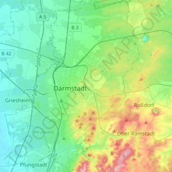
Name: Darmstadt topographic map, elevation, terrain.
Location: Darmstadt, Hesse, Germany (49.79567 8.55816 49.95380 8.74987)
Average elevation: 157 m
Minimum elevation: 89 m
Maximum elevation: 355 m
Other topographic maps
Click on a map to view its topography, its elevation and its terrain.
Aurorahütte
Germany > Hesse > Landkreis Marburg-Biedenkopf > Gladenbach > Erdhausen
Average elevation: 298 m
Saubach und Niedgesbach bei Schmitten
Germany > Hesse > Hochtaunuskreis > Finsternthal
Average elevation: 549 m
Bad Hersfeld
Germany > Hesse > Landkreis Hersfeld-Rotenburg
The Flugplatz Johannesberg has the status of Special Airfield. The runway, some 671 m long and 18 m wide, is paved with asphalt and oriented in a north–south direction. The airfield lies on the Johannesberg in the like-named outlying centre at an elevation of 284 m above sea level.
Average elevation: 281 m
Wiesbaden
The highest point of the Wiesbaden municipality is located northwest of the city center near the summit of the Hohe Wurzel, with an elevation of 608 metres (1,995 ft) above sea level. The lowest point is the harbour entrance of Schierstein at 83 metres (272 ft) above sea level. The central square (the…
Average elevation: 258 m
Teufelskadrich bei Lorch
Germany > Hesse > Rheingau-Taunus-Kreis > Rüdesheim am Rhein > Assmannshausen
Average elevation: 253 m
Wald-Michelbach
Germany > Hesse > Kreis Bergstraße > Wald-Michelbach > Wald-Michelbach
Average elevation: 396 m
Großer Feldberg
Germany > Hesse > Hochtaunuskreis > Schmitten im Taunus
The Großer Feldberg ("Great Field Mountain") is, at a height of 879.5 metres, the highest elevation of the Taunus mountains, and of the entire Rhenish Massif. It is situated in the Hochtaunuskreis district in Hesse, Germany.
Average elevation: 716 m
Seeheim-Jugenheim
Germany > Hesse > Landkreis Darmstadt-Dieburg > Seeheim-Jugenheim > Seeheim-Jugenheim
Average elevation: 213 m
Frankershausen
Germany > Hesse > Werra-Meißner-Kreis > Berkatal > Frankershausen
Average elevation: 291 m