
Kattappana topographic map
Interactive map
Click on the map to display elevation.
Kattappana
The average elevation of Kattappana Municipality is 950 m above sea level.
About this map
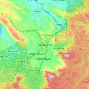
Name: Kattappana topographic map, elevation, terrain.
Location: Kattappana, Idukki, Kerala, 688508, India (9.71617 77.07406 9.79617 77.15406)
Average elevation: 950 m
Minimum elevation: 717 m
Maximum elevation: 1,276 m
Other topographic maps
Click on a map to view its topography, its elevation and its terrain.