Geolocate

Salitral topographic map

Interactive map

Click on the map to display elevation.

About this map

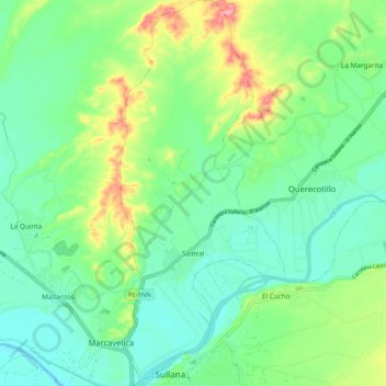
Name: Salitral topographic map, elevation, terrain.

Location: Salitral, Province of Sullana, Piura, Peru (-4.89318 -80.70093 -4.78932 -80.65640)

Average elevation: 65 m

Minimum elevation: 27 m

Maximum elevation: 154 m

Other topographic maps

Click on a map to view its topography, its elevation and its terrain.

Jilili

Peru > Piura > Jililí

Average elevation: 1,561 m

Sapalache

Peru > Piura > El Carmen de la Frontera

Average elevation: 2,478 m

Sicchez

Peru > Piura > Sícchez

Average elevation: 1,565 m

El Salto

Peru > Piura > Tambo Grande

Average elevation: 73 m

Mejia

Peru > Piura > Sullana

Average elevation: 77 m

Qf

Peru > Piura > 26 de Octubre

Average elevation: 41 m

Fb

Peru > Piura > 26 de Octubre

Average elevation: 40 m

Sicchez

Peru > Piura > Sícchez

Average elevation: 1,565 m

Pico de Loro

Peru > Piura > Jililí

Average elevation: 1,187 m

Frias

Peru > Piura > Frías

Average elevation: 1,846 m

Las Vegas

Peru > Piura > Sícchez

Average elevation: 1,272 m

Lobitos

Peru > Piura

Average elevation: 13 m

Nuevo Pozo Oscuro

Peru > Piura > Cristo nos Valga

Average elevation: 22 m

Talara

Peru > Piura > Pariñas

Average elevation: 42 m

Pico de Loro

Peru > Piura > Jililí

Average elevation: 1,187 m

Mancora

Peru > Piura > Máncora

Average elevation: 22 m

Chira

Peru > Piura > Sullana

Average elevation: 50 m

Narihualá

Peru > Piura > Catacaos

Average elevation: 22 m

Ayabaca

Peru > Piura > Distrito de Ayabaca

Average elevation: 2,368 m

El Tablazo

Peru > Piura > El Tablazo

Average elevation: 46 m

CA

Peru > Piura > Castilla

Average elevation: 35 m

Pico de Loro

Peru > Piura > Jililí

Average elevation: 1,187 m