
Make a donation
Gear up for your next adventure:
As an Amazon Associate, this site earns from qualifying purchases at no extra cost to you.
Cherwell District topographic map
Click on the map to display elevation.
Make a donation
Gear up for your next adventure:
As an Amazon Associate, this site earns from qualifying purchases at no extra cost to you.
About this map
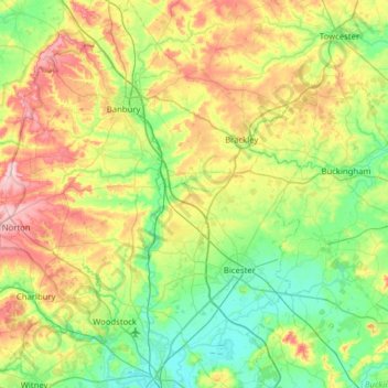
Name: Cherwell District topographic map, elevation, terrain.
Location: Cherwell District, Oxfordshire, England, United Kingdom (51.78096 -1.52284 52.16847 -1.04714)
Average elevation: 116 m
Minimum elevation: 56 m
Maximum elevation: 240 m
Oxfordshire trails, hiking, mountain biking, running and outdoor activities
Make a donation
Gear up for your next adventure:
As an Amazon Associate, this site earns from qualifying purchases at no extra cost to you.
Other topographic maps
Click on a map to view its topography, its elevation and its terrain.
Eynsham Mill
United Kingdom > England > Oxfordshire > West Oxfordshire > Eynsham
Average elevation: 71 m
Make a donation
Gear up for your next adventure:
As an Amazon Associate, this site earns from qualifying purchases at no extra cost to you.
White Horse Hill
United Kingdom > England > Oxfordshire > Vale of White Horse
Average elevation: 184 m
Mongewell
United Kingdom > England > Oxfordshire > South Oxfordshire > Crowmarsh Gifford
Average elevation: 59 m
Make a donation
Gear up for your next adventure:
As an Amazon Associate, this site earns from qualifying purchases at no extra cost to you.
Wittenham Clumps
United Kingdom > England > Oxfordshire > South Oxfordshire > Little Wittenham
Average elevation: 65 m
Make a donation
Gear up for your next adventure:
As an Amazon Associate, this site earns from qualifying purchases at no extra cost to you.
Make a donation
Gear up for your next adventure:
As an Amazon Associate, this site earns from qualifying purchases at no extra cost to you.
Overy
United Kingdom > England > Oxfordshire > South Oxfordshire > Dorchester-on-Thames
Average elevation: 55 m
Dorchester-on-Thames
United Kingdom > England > Oxfordshire > South Oxfordshire
Average elevation: 54 m
Make a donation
Gear up for your next adventure:
As an Amazon Associate, this site earns from qualifying purchases at no extra cost to you.
Cowleaze Wood
United Kingdom > England > Oxfordshire > South Oxfordshire > Lewknor
Average elevation: 209 m
Edmonds Park
United Kingdom > England > Oxfordshire > South Oxfordshire > Didcot > East Hagbourne
Average elevation: 68 m
Make a donation
Gear up for your next adventure:
As an Amazon Associate, this site earns from qualifying purchases at no extra cost to you.
Cane End
United Kingdom > England > Oxfordshire > South Oxfordshire > Gallowstree Common
Average elevation: 108 m
Roman Meadow Banbury Country Park
United Kingdom > England > Oxfordshire > Cherwell District > Little Bourton
Average elevation: 103 m
Woodperry
United Kingdom > England > Oxfordshire > South Oxfordshire > Stanton St John
Average elevation: 89 m
Make a donation
Gear up for your next adventure:
As an Amazon Associate, this site earns from qualifying purchases at no extra cost to you.
Kingston Stert
United Kingdom > England > Oxfordshire > South Oxfordshire > Aston Rowant
Average elevation: 96 m
Kingston Bagpuize
United Kingdom > England > Oxfordshire > Vale of White Horse
Average elevation: 76 m
Make a donation
Gear up for your next adventure:
As an Amazon Associate, this site earns from qualifying purchases at no extra cost to you.
Chinnor Quarry 2B
United Kingdom > England > Oxfordshire > South Oxfordshire > Kingston Blount > Crowell
Average elevation: 163 m
Ledwell
United Kingdom > England > Oxfordshire > West Oxfordshire > Sandford St. Martin
Average elevation: 142 m
Make a donation
Gear up for your next adventure:
As an Amazon Associate, this site earns from qualifying purchases at no extra cost to you.
Peppard Common
United Kingdom > England > Oxfordshire > South Oxfordshire > Rotherfield Peppard
Average elevation: 108 m
Nethercote
United Kingdom > England > Oxfordshire > Cherwell District > Banbury
Average elevation: 111 m
Make a donation
Gear up for your next adventure:
As an Amazon Associate, this site earns from qualifying purchases at no extra cost to you.
Hampton Gay
United Kingdom > England > Oxfordshire > Cherwell District > Shipton-on-Cherwell
Average elevation: 75 m
Little Chesterton
United Kingdom > England > Oxfordshire > Cherwell District > Wendlebury
Average elevation: 72 m
Make a donation
Gear up for your next adventure:
As an Amazon Associate, this site earns from qualifying purchases at no extra cost to you.
Make a donation
Gear up for your next adventure:
As an Amazon Associate, this site earns from qualifying purchases at no extra cost to you.
Make a donation
Gear up for your next adventure:
As an Amazon Associate, this site earns from qualifying purchases at no extra cost to you.
The Spinney
United Kingdom > England > Oxfordshire > Vale of White Horse > Kingston Bagpuize
Average elevation: 77 m
Make a donation
Gear up for your next adventure:
As an Amazon Associate, this site earns from qualifying purchases at no extra cost to you.
Christmas Common
United Kingdom > England > Oxfordshire > South Oxfordshire > Watlington
Christmas Common is a hamlet in Watlington civil parish, Oxfordshire about 7+1⁄2 miles (12 km) south of Thame in Oxfordshire, close to the boundary with Buckinghamshire. The hamlet is 812 feet (247 m) above sea level on an escarpment of the Chiltern Hills. Because of its elevation, Christmas Common has two…
Average elevation: 192 m
Waterperry
United Kingdom > England > Oxfordshire > South Oxfordshire > Waterstock
Average elevation: 63 m
Make a donation
Gear up for your next adventure:
As an Amazon Associate, this site earns from qualifying purchases at no extra cost to you.
Newnham Murren
United Kingdom > England > Oxfordshire > South Oxfordshire > Crowmarsh Gifford
Average elevation: 59 m
Kingwood Common
United Kingdom > England > Oxfordshire > South Oxfordshire > Highmoor
Average elevation: 125 m
Make a donation
Gear up for your next adventure:
As an Amazon Associate, this site earns from qualifying purchases at no extra cost to you.
Shipton-on-Cherwell
United Kingdom > England > Oxfordshire > Cherwell District
Average elevation: 78 m
Harpsden Wood
United Kingdom > England > Oxfordshire > South Oxfordshire > Henley-on-Thames > Harpsden
Average elevation: 63 m
Make a donation
Gear up for your next adventure:
As an Amazon Associate, this site earns from qualifying purchases at no extra cost to you.
Little Haseley
United Kingdom > England > Oxfordshire > South Oxfordshire > Great Haseley
Average elevation: 73 m
Baldon Row
United Kingdom > England > Oxfordshire > South Oxfordshire > Toot Baldon
Average elevation: 73 m
Make a donation
Gear up for your next adventure:
As an Amazon Associate, this site earns from qualifying purchases at no extra cost to you.
Little Lews
United Kingdom > England > Oxfordshire > Vale of White Horse > Ardington
Average elevation: 183 m
Gatehampton
United Kingdom > England > Oxfordshire > South Oxfordshire > Goring-on-Thames
Average elevation: 88 m
Make a donation
Gear up for your next adventure:
As an Amazon Associate, this site earns from qualifying purchases at no extra cost to you.
Sutton Wick
United Kingdom > England > Oxfordshire > Vale of White Horse > Abingdon > Drayton
Average elevation: 57 m
Wet n Wild Oxford
United Kingdom > England > Oxfordshire > South Oxfordshire > Berinsfield
Average elevation: 51 m
Make a donation
Gear up for your next adventure:
As an Amazon Associate, this site earns from qualifying purchases at no extra cost to you.
Great Park
United Kingdom > England > Oxfordshire > West Oxfordshire > Long Hanborough
Average elevation: 94 m
Lamborough Hill
United Kingdom > England > Oxfordshire > Vale of White Horse > Wootton
Average elevation: 92 m
Make a donation
Gear up for your next adventure:
As an Amazon Associate, this site earns from qualifying purchases at no extra cost to you.
Draycot
United Kingdom > England > Oxfordshire > South Oxfordshire > Tiddington
Average elevation: 68 m
Shipton-under-Wychwood
United Kingdom > England > Oxfordshire > West Oxfordshire
Average elevation: 131 m
Stoke Lyne
United Kingdom > England > Oxfordshire > Cherwell District > Stoke Lyne
Average elevation: 116 m
Make a donation
Gear up for your next adventure:
As an Amazon Associate, this site earns from qualifying purchases at no extra cost to you.
Chalkhouse Green
United Kingdom > England > Oxfordshire > South Oxfordshire > Kidmore End
Average elevation: 83 m
Boars Hill
United Kingdom > England > Oxfordshire > Vale of White Horse > Wootton
Average elevation: 106 m
Make a donation
Gear up for your next adventure:
As an Amazon Associate, this site earns from qualifying purchases at no extra cost to you.
Sutton Pools
United Kingdom > England > Oxfordshire > Vale of White Horse > Abingdon > Sutton Courtenay
Average elevation: 54 m
Carswell Marsh
United Kingdom > England > Oxfordshire > Vale of White Horse > Buckland
Average elevation: 80 m
Make a donation
Gear up for your next adventure:
As an Amazon Associate, this site earns from qualifying purchases at no extra cost to you.
Ewelme Park
United Kingdom > England > Oxfordshire > South Oxfordshire > Swyncombe
Average elevation: 172 m
Down End
United Kingdom > England > Oxfordshire > Cherwell District > Hook Norton
Average elevation: 173 m
Sonning Eye
United Kingdom > England > Oxfordshire > South Oxfordshire > Dunsden Green > Sonning Eye
Average elevation: 44 m
Make a donation
Gear up for your next adventure:
As an Amazon Associate, this site earns from qualifying purchases at no extra cost to you.