
Make a donation
Gear up for your next adventure:
As an Amazon Associate, this site earns from qualifying purchases at no extra cost to you.
Collins End topographic map
Click on the map to display elevation.
Make a donation
Gear up for your next adventure:
As an Amazon Associate, this site earns from qualifying purchases at no extra cost to you.
About this map
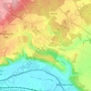
Name: Collins End topographic map, elevation, terrain.
Average elevation: 99 m
Minimum elevation: 35 m
Maximum elevation: 178 m
Oxfordshire trails, hiking, mountain biking, running and outdoor activities
Make a donation
Gear up for your next adventure:
As an Amazon Associate, this site earns from qualifying purchases at no extra cost to you.
Other topographic maps
Click on a map to view its topography, its elevation and its terrain.
Clifton Hampden
United Kingdom > England > Oxfordshire > South Oxfordshire > Clifton Hampden
Average elevation: 58 m
Make a donation
Gear up for your next adventure:
As an Amazon Associate, this site earns from qualifying purchases at no extra cost to you.
Harpsden Wood
United Kingdom > England > Oxfordshire > South Oxfordshire > Henley-on-Thames > Harpsden
Average elevation: 63 m
Watlington Hill
United Kingdom > England > Oxfordshire > South Oxfordshire > Watlington
Average elevation: 189 m
Kingwood Common
United Kingdom > England > Oxfordshire > South Oxfordshire > Highmoor
Average elevation: 125 m
Make a donation
Gear up for your next adventure:
As an Amazon Associate, this site earns from qualifying purchases at no extra cost to you.
Goring-on-Thames
United Kingdom > England > Oxfordshire > South Oxfordshire > Goring-on-Thames
Average elevation: 87 m
Cowleaze Wood
United Kingdom > England > Oxfordshire > South Oxfordshire > Lewknor
Average elevation: 209 m
Make a donation
Gear up for your next adventure:
As an Amazon Associate, this site earns from qualifying purchases at no extra cost to you.
Sonning Eye
United Kingdom > England > Oxfordshire > South Oxfordshire > Dunsden Green > Sonning Eye
Average elevation: 44 m
Make a donation
Gear up for your next adventure:
As an Amazon Associate, this site earns from qualifying purchases at no extra cost to you.
Make a donation
Gear up for your next adventure:
As an Amazon Associate, this site earns from qualifying purchases at no extra cost to you.
Drayton St. Leonard
United Kingdom > England > Oxfordshire > South Oxfordshire
Average elevation: 54 m
Brightwell-cum-Sotwell
United Kingdom > England > Oxfordshire > South Oxfordshire
Average elevation: 54 m
Make a donation
Gear up for your next adventure:
As an Amazon Associate, this site earns from qualifying purchases at no extra cost to you.
Make a donation
Gear up for your next adventure:
As an Amazon Associate, this site earns from qualifying purchases at no extra cost to you.
Make a donation
Gear up for your next adventure:
As an Amazon Associate, this site earns from qualifying purchases at no extra cost to you.
Kidmore End
United Kingdom > England > Oxfordshire > South Oxfordshire > Kidmore End
Average elevation: 94 m
Horspath
United Kingdom > England > Oxfordshire > South Oxfordshire > Horspath
Average elevation: 105 m
Make a donation
Gear up for your next adventure:
As an Amazon Associate, this site earns from qualifying purchases at no extra cost to you.
Chinnor Quarry 2B
United Kingdom > England > Oxfordshire > South Oxfordshire > Kingston Blount > Crowell
Average elevation: 163 m
Whitchurch-on-Thames
United Kingdom > England > Oxfordshire > South Oxfordshire > Whitchurch-on-Thames
Average elevation: 84 m
Make a donation
Gear up for your next adventure:
As an Amazon Associate, this site earns from qualifying purchases at no extra cost to you.
Edmonds Park
United Kingdom > England > Oxfordshire > South Oxfordshire > Didcot > East Hagbourne
Average elevation: 68 m
Rotherfield Peppard
United Kingdom > England > Oxfordshire > South Oxfordshire > Rotherfield Peppard
Average elevation: 115 m
Make a donation
Gear up for your next adventure:
As an Amazon Associate, this site earns from qualifying purchases at no extra cost to you.
Shirburn
United Kingdom > England > Oxfordshire > South Oxfordshire
Shirburn is a village and civil parish about 6 miles (10 km) south of Thame in Oxfordshire. It contains the Grade I listed, 14th-century Shirburn Castle, along with its surrounding, Grade II listed park, and a parish church, the oldest part of which is from the Norman period. The parish has a high altitude by…
Average elevation: 140 m
Make a donation
Gear up for your next adventure:
As an Amazon Associate, this site earns from qualifying purchases at no extra cost to you.
Brightwell Baldwin
United Kingdom > England > Oxfordshire > South Oxfordshire > Cuxham
Average elevation: 97 m
Sonning Common
United Kingdom > England > Oxfordshire > South Oxfordshire > Sonning Common
Average elevation: 88 m
Make a donation
Gear up for your next adventure:
As an Amazon Associate, this site earns from qualifying purchases at no extra cost to you.
Make a donation
Gear up for your next adventure:
As an Amazon Associate, this site earns from qualifying purchases at no extra cost to you.
East Hagbourne
United Kingdom > England > Oxfordshire > South Oxfordshire > East Hagbourne
Average elevation: 62 m
Make a donation
Gear up for your next adventure:
As an Amazon Associate, this site earns from qualifying purchases at no extra cost to you.
Stanton St John
United Kingdom > England > Oxfordshire > South Oxfordshire > Stanton St John
Average elevation: 86 m
Make a donation
Gear up for your next adventure:
As an Amazon Associate, this site earns from qualifying purchases at no extra cost to you.
Make a donation
Gear up for your next adventure:
As an Amazon Associate, this site earns from qualifying purchases at no extra cost to you.
Swyncombe
United Kingdom > England > Oxfordshire > South Oxfordshire > Swyncombe
Average elevation: 174 m
Aston Rowant Nature Reserve
United Kingdom > England > Oxfordshire > South Oxfordshire > Lewknor
Average elevation: 192 m
Make a donation
Gear up for your next adventure:
As an Amazon Associate, this site earns from qualifying purchases at no extra cost to you.
Warborough
United Kingdom > England > Oxfordshire > South Oxfordshire > Warborough
Average elevation: 53 m
Drayton St. Leonard
United Kingdom > England > Oxfordshire > South Oxfordshire
Average elevation: 54 m
Make a donation
Gear up for your next adventure:
As an Amazon Associate, this site earns from qualifying purchases at no extra cost to you.
Holly Wood
United Kingdom > England > Oxfordshire > South Oxfordshire > Stanton St John
Average elevation: 80 m
Make a donation
Gear up for your next adventure:
As an Amazon Associate, this site earns from qualifying purchases at no extra cost to you.