
Juneau County topographic map
Click on the map to display elevation.
About this map
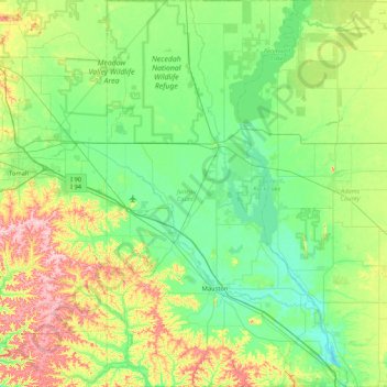
Name: Juneau County topographic map, elevation, terrain.
Location: Juneau County, Wisconsin, United States (43.64070 -90.31282 44.24971 -89.78526)
Average elevation: 302 m
Minimum elevation: 253 m
Maximum elevation: 441 m
Other topographic maps
Click on a map to view its topography, its elevation and its terrain.
Milwaukee River Floodplain Forest State Natural Area
United States > Wisconsin > Washington County
Average elevation: 291 m
Observatory Hill State Natural Area
United States > Wisconsin > Marquette County
Average elevation: 262 m
Parfrey's Glen State Natural Area
United States > Wisconsin > Sauk County > Town of Merrimac
Average elevation: 360 m
Land O' Lakes
United States > Wisconsin > Vilas County > Town of Land O' Lakes
Average elevation: 524 m
Pell Lake
United States > Wisconsin > Walworth County > Village of Bloomfield
Average elevation: 263 m
Blue Mound State Park
United States > Wisconsin > Iowa County > Town of Brigham
Average elevation: 416 m
Northern Wisconsin State Fairgrounds
United States > Wisconsin > Chippewa County > Chippewa Falls
Average elevation: 279 m
Wildcat Mountain State Park
United States > Wisconsin > Vernon County > Town of Whitestown
Average elevation: 310 m
Rattlesnake Point
United States > Wisconsin > Crawford County > Town of Marietta
Average elevation: 232 m
Goll
United States > Wisconsin > Marinette County > Town of Wagner
Goll is located at the intersection of County Trunk Highway X and Old Rail Road (formerly Right of Way Road), at an elevation of 702 feet (214 m). It is connected by road to Wagner to the north, Middle Inlet to the west, and Wisconsin Highway 180 to the east. Goll Road runs obliquely to the east of the former…
Average elevation: 210 m
Rattlesnake Point
United States > Wisconsin > Crawford County > Town of Marietta
Average elevation: 232 m
Black River Falls
United States > Wisconsin > Jackson County > Black River Falls
Average elevation: 264 m
Yellowstone Lake State Park
United States > Wisconsin > Lafayette County > Blanchardville > Town of Fayette
Average elevation: 288 m
George W Mead State Wildlife Management Area
United States > Wisconsin > Marathon County > Town of Bergen
Average elevation: 343 m
Englewood
United States > Wisconsin > Columbia County > Town of Fountain Prairie
Average elevation: 276 m
Perrot State Park
United States > Wisconsin > Trempealeau County > Town of Trempealeau
Average elevation: 223 m
Wildcat Mountain State Park
United States > Wisconsin > Vernon County > Town of Whitestown
Average elevation: 310 m
Menomonee Falls
United States > Wisconsin > Waukesha County > Menomonee Falls
Average elevation: 260 m