
Make a donation
Gear up for your next adventure:
As an Amazon Associate, this site earns from qualifying purchases at no extra cost to you.
Kelso topographic map
Click on the map to display elevation.
Make a donation
Gear up for your next adventure:
As an Amazon Associate, this site earns from qualifying purchases at no extra cost to you.
About this map
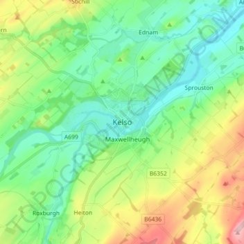
Name: Kelso topographic map, elevation, terrain.
Location: Kelso, Scottish Borders, Scotland, TD5 7HG, United Kingdom (55.55838 -2.47384 55.63838 -2.39384)
Average elevation: 79 m
Minimum elevation: 22 m
Maximum elevation: 210 m
Scottish Borders trails, hiking, mountain biking, running and outdoor activities
Make a donation
Gear up for your next adventure:
As an Amazon Associate, this site earns from qualifying purchases at no extra cost to you.
Other topographic maps
Click on a map to view its topography, its elevation and its terrain.
Hirsel Lake
United Kingdom > Scotland > Scottish Borders > Coldstream > The Hirsel
Average elevation: 37 m
Make a donation
Gear up for your next adventure:
As an Amazon Associate, this site earns from qualifying purchases at no extra cost to you.
Make a donation
Gear up for your next adventure:
As an Amazon Associate, this site earns from qualifying purchases at no extra cost to you.
Greenknowe Tower
United Kingdom > Scotland > Scottish Borders > Gordon > Nether Huntlywood
Average elevation: 157 m
Make a donation
Gear up for your next adventure:
As an Amazon Associate, this site earns from qualifying purchases at no extra cost to you.
Curling Pond
United Kingdom > Scotland > Scottish Borders > Earlston > Georgefield
Average elevation: 153 m