Geolocate

Galashiels topographic map

Interactive map

Click on the map to display elevation.

About this map

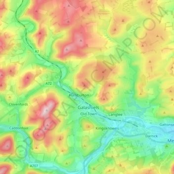
Name: Galashiels topographic map, elevation, terrain.

Location: Galashiels, Scottish Borders, Scotland, United Kingdom (55.57887 -2.86204 55.67654 -2.75064)

Average elevation: 221 m

Minimum elevation: 83 m

Maximum elevation: 423 m

Scottish Borders trails, hiking, mountain biking, running and outdoor activities

Other topographic maps

Click on a map to view its topography, its elevation and its terrain.

Hownam

United Kingdom > Scotland > Scottish Borders

Average elevation: 234 m

Oxnam

United Kingdom > Scotland > Scottish Borders

Average elevation: 171 m

Rubers Law

United Kingdom > Scotland > Scottish Borders

Average elevation: 229 m

Furlongs

United Kingdom > Scotland > Scottish Borders > Ancrum

Average elevation: 108 m

Peebles

United Kingdom > Scotland > Scottish Borders

Average elevation: 275 m

Heugh Head

United Kingdom > Scotland > Scottish Borders > Reston

Average elevation: 111 m

Cringletie

United Kingdom > Scotland > Scottish Borders

Average elevation: 257 m

Abbey St. Bathans

United Kingdom > Scotland > Scottish Borders

Abbey St Bathans (Scottish Gaelic: Abaid Bhaoithin) is a parish in the Lammermuir district of Berwickshire, in the eastern part of the Scottish Borders. Unique in its topography, it is situated in a long winding steep wooded valley that follows the Whiteadder Water. The parish had a population of 106 at the…

Average elevation: 212 m

Doghill

United Kingdom > Scotland > Scottish Borders > Kelso > Spylaw

Average elevation: 87 m

Darnick

United Kingdom > Scotland > Scottish Borders

Average elevation: 160 m

Broughton

United Kingdom > Scotland > Scottish Borders

Average elevation: 268 m

Nenthorn

United Kingdom > Scotland > Scottish Borders

Average elevation: 126 m

Greenknowe

United Kingdom > Scotland > Scottish Borders > Gordon

Average elevation: 170 m

Coldstream

United Kingdom > Scotland > Scottish Borders

Average elevation: 52 m

Bridgend

United Kingdom > Scotland > Scottish Borders > Tweedbank

Average elevation: 157 m

Ednam

United Kingdom > Scotland > Scottish Borders

Average elevation: 56 m

Stichill

United Kingdom > Scotland > Scottish Borders

Average elevation: 100 m

Skirling

United Kingdom > Scotland > Scottish Borders

Average elevation: 249 m

Crossrig

United Kingdom > Scotland > Scottish Borders

Average elevation: 60 m

Tweedsmuir

United Kingdom > Scotland > Scottish Borders

Average elevation: 346 m

Minto

United Kingdom > Scotland > Scottish Borders

Average elevation: 131 m

Fogomoor

United Kingdom > Scotland > Scottish Borders > Fogo

Average elevation: 119 m

Hawick

United Kingdom > Scotland > Scottish Borders

Average elevation: 199 m

Dewar Hill

United Kingdom > Scotland > Scottish Borders

Average elevation: 459 m

Wauchope

United Kingdom > Scotland > Scottish Borders

Average elevation: 239 m

Knock Hill

United Kingdom > Scotland > Scottish Borders

Average elevation: 279 m

Carlops

United Kingdom > Scotland > Scottish Borders

Average elevation: 340 m

Gordon

United Kingdom > Scotland > Scottish Borders

Average elevation: 159 m

Wormington

United Kingdom > Scotland > Scottish Borders

Average elevation: 172 m

Newstead

United Kingdom > Scotland > Scottish Borders

Average elevation: 157 m

Crailing

United Kingdom > Scotland > Scottish Borders

Average elevation: 92 m

Ashkirk

United Kingdom > Scotland > Scottish Borders

Average elevation: 238 m

Steele Road

United Kingdom > Scotland > Scottish Borders

Average elevation: 185 m

Legerwood

United Kingdom > Scotland > Scottish Borders

Average elevation: 212 m

Clerklands

United Kingdom > Scotland > Scottish Borders

Average elevation: 212 m

Denholm

United Kingdom > Scotland > Scottish Borders

In Main Street, stands The Text House, a category B listed building, erected about 1910 by John Haddon (1845–1924), a medical doctor and author of published works on public sanitation and dietetics. The 3-storey house is in the arts and craft style. One of the texts on the front elevation is a reminder to…

Average elevation: 128 m

Darny Rig

United Kingdom > Scotland > Scottish Borders

Average elevation: 326 m

Hopehouse

United Kingdom > Scotland > Scottish Borders

Average elevation: 321 m

Eddleston

United Kingdom > Scotland > Scottish Borders

Average elevation: 282 m

Fens

United Kingdom > Scotland > Scottish Borders > St Boswells

Average elevation: 96 m

Muirfield

United Kingdom > Scotland > Scottish Borders

Average elevation: 227 m

Kilbucho

United Kingdom > Scotland > Scottish Borders

Average elevation: 269 m

Roxburgh

United Kingdom > Scotland > Scottish Borders

Average elevation: 82 m

Charterhall

United Kingdom > Scotland > Scottish Borders

Average elevation: 117 m

Penmanshiel

United Kingdom > Scotland > Scottish Borders

Average elevation: 179 m

Graden

United Kingdom > Scotland > Scottish Borders

Average elevation: 177 m

Earnslaw

United Kingdom > Scotland > Scottish Borders

Average elevation: 68 m

Lyne

United Kingdom > Scotland > Scottish Borders

Average elevation: 239 m

East Middle

United Kingdom > Scotland > Scottish Borders

Average elevation: 156 m

Black Hill

United Kingdom > Scotland > Scottish Borders

Average elevation: 273 m

Greenlaw

United Kingdom > Scotland > Scottish Borders

Average elevation: 179 m

Jedburgh

United Kingdom > Scotland > Scottish Borders

Average elevation: 151 m

Cranshaws

United Kingdom > Scotland > Scottish Borders

Average elevation: 263 m

Chirnside

United Kingdom > Scotland > Scottish Borders

Average elevation: 80 m

Stobo

United Kingdom > Scotland > Scottish Borders

Average elevation: 271 m

Dryhope

United Kingdom > Scotland > Scottish Borders

Average elevation: 353 m

Falahill

United Kingdom > Scotland > Scottish Borders

Average elevation: 307 m

Ayton

United Kingdom > Scotland > Scottish Borders

Average elevation: 75 m

Cavers

United Kingdom > Scotland > Scottish Borders

Average elevation: 157 m

Kelso

United Kingdom > Scotland > Scottish Borders

Average elevation: 79 m

Kirkton

United Kingdom > Scotland > Scottish Borders

Average elevation: 204 m

Lauder

United Kingdom > Scotland > Scottish Borders

Average elevation: 207 m

Heriot

United Kingdom > Scotland > Scottish Borders

Average elevation: 323 m

Newmill

United Kingdom > Scotland > Scottish Borders

Average elevation: 211 m

West Linton

United Kingdom > Scotland > Scottish Borders

Average elevation: 264 m

Faldonside

United Kingdom > Scotland > Scottish Borders

Average elevation: 177 m

Wooden

United Kingdom > Scotland > Scottish Borders > Kelso

Average elevation: 72 m

Thickside

United Kingdom > Scotland > Scottish Borders

Average elevation: 157 m

Midlem

United Kingdom > Scotland > Scottish Borders

Average elevation: 204 m

Bellspool

United Kingdom > Scotland > Scottish Borders

Average elevation: 264 m

Burnmouth

United Kingdom > Scotland > Scottish Borders

Average elevation: 63 m

Lempitlaw

United Kingdom > Scotland > Scottish Borders

Average elevation: 159 m

Clovenfords

United Kingdom > Scotland > Scottish Borders

Average elevation: 239 m

Drumelzier

United Kingdom > Scotland > Scottish Borders

Average elevation: 273 m

Whitmuir

United Kingdom > Scotland > Scottish Borders

Average elevation: 296 m

Hume Orchard

United Kingdom > Scotland > Scottish Borders > Hume

Average elevation: 156 m

Boon

United Kingdom > Scotland > Scottish Borders

Average elevation: 218 m