
Lempitlaw topographic map
Interactive map
Click on the map to display elevation.
About this map
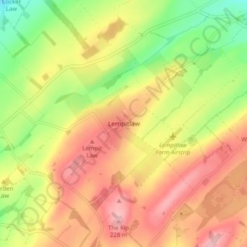
Name: Lempitlaw topographic map, elevation, terrain.
Location: Lempitlaw, Scottish Borders, Scotland, TD5 8BN, United Kingdom (55.56763 -2.35955 55.60763 -2.31955)
Average elevation: 159 m
Minimum elevation: 81 m
Maximum elevation: 224 m
Scottish Borders trails, hiking, mountain biking, running and outdoor activities
Other topographic maps
Click on a map to view its topography, its elevation and its terrain.
Greenknowe Tower
United Kingdom > Scotland > Scottish Borders > Gordon > Nether Huntlywood
Average elevation: 157 m
Curling Pond
United Kingdom > Scotland > Scottish Borders > Earlston > Georgefield
Average elevation: 153 m