
Denholm topographic map
Interactive map
Click on the map to display elevation.
Denholm
In Main Street, stands The Text House, a category B listed building, erected about 1910 by John Haddon (1845–1924), a medical doctor and author of published works on public sanitation and dietetics. The 3-storey house is in the arts and craft style. One of the texts on the front elevation is a reminder to take care with time before it passes, "TAK TENT IN TIME ~ ERE TIME BE TINT", the other text reminds the occupier that there were and will be others living in the house, "ALL WAS OTHERS ~ ALL WILL BE OTHERS".
About this map
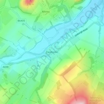
Name: Denholm topographic map, elevation, terrain.
Location: Denholm, Scottish Borders, Scotland, TD9 8NU, United Kingdom (55.43804 -2.70362 55.47804 -2.66362)
Average elevation: 128 m
Minimum elevation: 65 m
Maximum elevation: 307 m
Scottish Borders trails, hiking, mountain biking, running and outdoor activities
Other topographic maps
Click on a map to view its topography, its elevation and its terrain.
Greenknowe Tower
United Kingdom > Scotland > Scottish Borders > Gordon > Nether Huntlywood
Average elevation: 157 m
Curling Pond
United Kingdom > Scotland > Scottish Borders > Earlston > Georgefield
Average elevation: 153 m