
County Antrim topographic map
Interactive map
Click on the map to display elevation.
County Antrim
A large portion of Antrim is hilly, especially in the east, where the highest elevations are attained. The range runs north and south, and, following this direction, the highest points are Knocklayd 514 m (1,690 ft), Slieveanorra 508 m (1,670 ft), Trostan 550 m (1,800 ft), Slemish 437 m (1,430 ft), Agnew's Hill 474 m (1,560 ft) and Divis 478 m (1,570 ft). The inland slope is gradual, but on the northern shore the range terminates in abrupt and almost perpendicular declivities, and here, consequently, some of the finest coast scenery in the world is found, widely differing, with its unbroken lines of cliffs, from the indented coast-line of the west. The most remarkable cliffs are those formed of perpendicular basaltic columns, extending for many miles, and most strikingly displayed in Fair Head and the celebrated Giant's Causeway. From the eastern coast the hills rise instantly but less abruptly, and the indentations are wider and deeper. On both coasts there are several resort towns, including Portrush (with well-known golf links), Portballintrae and Ballycastle; on the east Cushendun, Cushendall and Waterfoot on Red Bay, Carnlough and Glenarm, Larne on the Sea of Moyle, and Whitehead on Belfast Lough. All are somewhat exposed to the easterly winds prevalent in spring. The only island of size is the L-shaped Rathlin Island, off Ballycastle, 11 km (6.8 mi) in total length by 2 km (1.2 mi) maximum breadth, 7 km (4.3 mi) from the coast, and of similar basaltic and limestone formation to that of the mainland. It is partially arable, and supports a small population. Islandmagee is a peninsula separating Larne Lough from the North Channel.
About this map
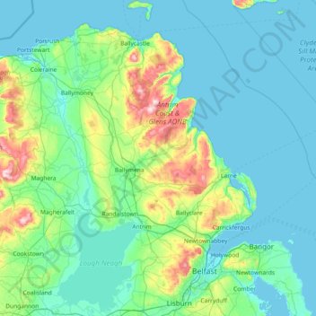
Name: County Antrim topographic map, elevation, terrain.
Location: County Antrim, Northern Ireland, United Kingdom (54.47728 -6.66899 55.31309 -5.68796)
Average elevation: 70 m
Minimum elevation: -1 m
Maximum elevation: 549 m
Northern Ireland trails, hiking, mountain biking, running and outdoor activities
Other topographic maps
Click on a map to view its topography, its elevation and its terrain.
Derry/Londonderry
United Kingdom > Northern Ireland > County Londonderry
Derry is characterised by its distinctively hilly topography. The River Foyle forms a deep valley as it flows through the city, making Derry a place of very steep streets and sudden, startling views. The original walled city of Londonderry lies on a hill on the west bank of the River Foyle. In the past, the…
Average elevation: 88 m
Lagan Navigation (Abandoned)
United Kingdom > Northern Ireland > County Antrim > Belfast
Average elevation: 29 m
Magheramorne
United Kingdom > Northern Ireland > County Antrim > Craigstown Meadow
Average elevation: 32 m
Ederney
United Kingdom > Northern Ireland > County Fermanagh
By 1797, the settlement is recorded in the Topographia Hibernica as Ederny Bridge and "fair days" were held there.
Average elevation: 91 m
Loughgiel Millennium Centre
United Kingdom > Northern Ireland > County Antrim > Loughguile
Average elevation: 155 m
Castlecaufield
United Kingdom > Northern Ireland > County Tyrone > Castlecaulfield
Average elevation: 95 m