
Candlemas Island topographic map
Interactive map
Click on the map to display elevation.
About this map
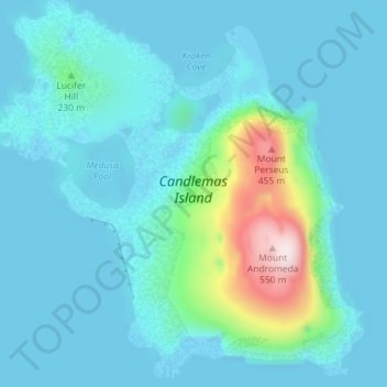
Name: Candlemas Island topographic map, elevation, terrain.
Average elevation: 63 m
Minimum elevation: 0 m
Maximum elevation: 485 m
Other topographic maps
Click on a map to view its topography, its elevation and its terrain.
Zavodovski Island
South Georgia and the South Sandwich Islands > South Sandwich Islands
Zavodovski Island, South Sandwich Islands, South Georgia and the South Sandwich Islands
Average elevation: 50 m
South Sandwich Islands
South Georgia and the South Sandwich Islands > South Sandwich Islands
South Sandwich Islands, South Georgia and the South Sandwich Islands
Average elevation: 1 m
Cook Island
South Georgia and the South Sandwich Islands > South Sandwich Islands
Cook Island, South Sandwich Islands, South Georgia and the South Sandwich Islands
Average elevation: 201 m