
Gelligaer topographic map
Interactive map
Click on the map to display elevation.
About this map
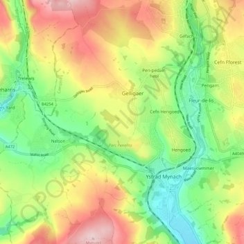
Name: Gelligaer topographic map, elevation, terrain.
Location: Gelligaer, Caerphilly, Wales, United Kingdom (51.62377 -3.28879 51.68874 -3.22026)
Average elevation: 202 m
Minimum elevation: 87 m
Maximum elevation: 351 m
Other topographic maps
Click on a map to view its topography, its elevation and its terrain.
Parc Penallta
United Kingdom > Wales > Gelligaer
Parc Penallta, Gelligaer, Caerphilly, Wales, United Kingdom
Average elevation: 188 m