
Make a donation
Gear up for your next adventure:
As an Amazon Associate, this site earns from qualifying purchases at no extra cost to you.
Summit County topographic map
Click on the map to display elevation.
Make a donation
Gear up for your next adventure:
As an Amazon Associate, this site earns from qualifying purchases at no extra cost to you.
Summit County
The terrain of the county is mountainous with elevations ranging from 7,957 feet (2,425 m) at Green Mountain Reservoir to 14,270 feet (4,350 m) at Grays Peak. The elevation of the county seat of Breckenridge is 9,602 feet (2,927 m), making it one of the highest cities in the state of Colorado and the United States. Much of the county has an Alpine (ET in the Köppen Classification) characterized by tundra vegetation. Breckenridge and other similar elevations in the county have a Subarctic climate (Dfc) characterized by cool summers and abundant snowfall in winter.
Make a donation
Gear up for your next adventure:
As an Amazon Associate, this site earns from qualifying purchases at no extra cost to you.
About this map
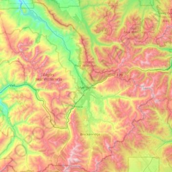
Name: Summit County topographic map, elevation, terrain.
Location: Summit County, Colorado, United States (39.35736 -106.43592 39.92489 -105.77582)
Average elevation: 3,222 m
Minimum elevation: 2,336 m
Maximum elevation: 4,343 m
Make a donation
Gear up for your next adventure:
As an Amazon Associate, this site earns from qualifying purchases at no extra cost to you.
Other topographic maps
Click on a map to view its topography, its elevation and its terrain.
Estes Park
United States > Colorado > Larimer County
Estes Park sits at an elevation of 7,522 feet (2,293 m) on the front range of the Rocky Mountains at the eastern entrance of the Rocky Mountain National Park. Its north, south and east extremities border the Roosevelt National Forest. Lumpy Ridge lies immediately north of Estes Park.
Average elevation: 2,543 m
Buena Vista
United States > Colorado > Chaffee County
Buena Vista is located in central Colorado roughly midway between Salida and Leadville in the Upper Arkansas River Valley at an elevation of 7,965 feet (2,428 m). The area between Buena Vista and Salida is often referred to as the Denver & Rio Grande, South Park & Pacific, and Colorado Midland railroads. Many…
Average elevation: 2,457 m
Make a donation
Gear up for your next adventure:
As an Amazon Associate, this site earns from qualifying purchases at no extra cost to you.
Evergreen
United States > Colorado > Jefferson County
Evergreen sits at an elevation of 7,220 feet (2,200 m) in the Rocky Mountains, 19 miles west of Denver, Colorado. Its addresses are oriented according to the Street_system_of_Denver.
Average elevation: 2,309 m
Lakewood
United States > Colorado > Jefferson County > Lakewood
Lakewood is located at 39°42′17″N 105°04′53″W / 39.70472°N 105.08139°W / 39.70472; -105.08139 at an elevation of 5,518 feet (1,682 m). Located at the junction of U.S. Route 6 and Colorado State Highway 121 in central Colorado, the city lies immediately west of Denver and 62 miles (100 km)…
Average elevation: 1,717 m
Make a donation
Gear up for your next adventure:
As an Amazon Associate, this site earns from qualifying purchases at no extra cost to you.
Grand Lake
United States > Colorado > Grand County
Established in 1881, Grand Lake sits at an elevation of 8,369 feet (2,551 m) and derives its name from the lake on whose shores it is situated: Grand Lake, the largest natural body of water in Colorado. The town of Grand Lake was originally an outfitting and supply point for the mining settlements of Lulu…
Average elevation: 2,630 m
Make a donation
Gear up for your next adventure:
As an Amazon Associate, this site earns from qualifying purchases at no extra cost to you.
Rogers Pass
United States > Colorado > Gilpin County
Rogers Pass, elevation 11,866 ft (3,617 m), is a mountain pass in the Front Range of central Colorado. The pass crosses the continental divide in the James Peak Wilderness.
Average elevation: 3,448 m
Mount Massive
United States > Colorado > Lake County
A class 2 hiking path leads to the peak from the eastern face. The path is 13.6 mi (21.9 km) round trip, with a 4,500 ft (1,400 m) elevation gain. There is also a class 2 route along the southwest slopes.
Average elevation: 4,021 m
Make a donation
Gear up for your next adventure:
As an Amazon Associate, this site earns from qualifying purchases at no extra cost to you.
Mount Elbert
United States > Colorado > Lake County
Mount Elbert is composed largely of quartzite. However, the summit ridge consists of metamorphic basement rock, which is Pre-Cambrian in origin and about 1.7 billion years old. There are various igneous intrusions including pegmatite, as well as bands of gneiss and schist. Unlike mountains of similar altitude…
Average elevation: 3,959 m
Crested Butte
United States > Colorado > Gunnison County
Crested Butte is located in north-central Gunnison County on the west side of the valley of the Slate River, along Coal Creek. Colorado State Highway 135 runs south from Crested Butte 27 miles (43 km) to Gunnison, the county seat. According to the United States Census Bureau, the town of Crested Butte has a…
Average elevation: 2,798 m
Make a donation
Gear up for your next adventure:
As an Amazon Associate, this site earns from qualifying purchases at no extra cost to you.
Cheyenne Mountain State Park
United States > Colorado > El Paso County > Colorado Springs
Average elevation: 2,142 m
Fairplay
United States > Colorado > Park County
The historic Town of Fairplay is the Statutory Town that is the county seat and the most populous municipality of Park County, Colorado, United States. The town population was 724 at the 2020 United States Census. Fairplay is located in South Park at an elevation of 9,953 feet (3,034 m). The town is the…
Average elevation: 3,045 m
Make a donation
Gear up for your next adventure:
As an Amazon Associate, this site earns from qualifying purchases at no extra cost to you.
Fairplay
United States > Colorado > Park County
The historic Town of Fairplay is the Statutory Town that is the county seat and the most populous municipality of Park County, Colorado, United States. The town population was 724 at the 2020 United States Census. Fairplay is located in South Park at an elevation of 9,953 feet (3,034 m). The town is the…
Average elevation: 3,045 m
Ouray
United States > Colorado > Ouray County
Ouray (/ˈjʊəreɪ/ YOOR-ay) is a home rule municipality that is the county seat of Ouray County, Colorado, United States. The city population was 898 as of the 2020 census. The Ouray Post Office has the ZIP Code 81427. Located at an elevation of 7,792 feet (2,375 m), Ouray's climate, natural alpine…
Average elevation: 2,717 m
Make a donation
Gear up for your next adventure:
As an Amazon Associate, this site earns from qualifying purchases at no extra cost to you.
Mountain Village
United States > Colorado > San Miguel County
Mountain Village is a home rule municipality in San Miguel County, southwestern Colorado. It is located just southwest of Telluride, Colorado in the San Juan Mountains. The elevation of the town rises above Telluride to 9,600 feet. The population was 1,264 at the 2020 census.
Average elevation: 2,917 m
Make a donation
Gear up for your next adventure:
As an Amazon Associate, this site earns from qualifying purchases at no extra cost to you.
Mount Blue Sky
United States > Colorado > Clear Creek County
The history of the Mount Evans Scenic Byway is part of a larger story of the Denver Mountain Parks system. The City and County of Denver initiated the construction of a series of automobile "scenic loops" to allow Denverites to explore the mountains. One road circuit, Circle G, was to traverse the ridge to…
Average elevation: 4,006 m
Make a donation
Gear up for your next adventure:
As an Amazon Associate, this site earns from qualifying purchases at no extra cost to you.
Animas Forks
United States > Colorado > San Juan County
Animas Forks is located on a system of roads known as the Alpine Loop. The loop is a 65-mile (105 km) system of unpaved roads which connects the small mountain towns of Lake City, Ouray, and Silverton. Most of the land in the area is managed by either the U.S. Forest Service or the Bureau of Land Management.…
Average elevation: 3,636 m
Make a donation
Gear up for your next adventure:
As an Amazon Associate, this site earns from qualifying purchases at no extra cost to you.
Monarch Pass
United States > Colorado > Gunnison County
Monarch Pass (elevation 11,312 feet (3,448 m)) is a high mountain pass in central Colorado, in the Rocky Mountains of the western United States.
Average elevation: 3,419 m
Crestone Peak
United States > Colorado > Saguache County
Generally climbs of Crestone Peak or Crestone Needle start from a base camp at South Colony Lakes, east of the peak, accessed from the Wet Mountain Valley on the northeast side of the range. This route involves nearly 6,000 ft (1,800 m) of elevation gain, and ascends to a large relatively flat area called "The…
Average elevation: 3,875 m
Make a donation
Gear up for your next adventure:
As an Amazon Associate, this site earns from qualifying purchases at no extra cost to you.
Vail
United States > Colorado > Eagle County
Vail's average elevation is 8,150 feet (2484 m) above sea level. The town has a total area of 4.5 square miles (12 km2), with no lakes (there is, however, at least one pond). Gore Creek flows from east to west through the center of town.
Average elevation: 2,953 m
Estes Park
United States > Colorado > Larimer County
Estes Park sits at an elevation of 7,522 feet (2,293 m) on the front range of the Rocky Mountains at the eastern entrance of the Rocky Mountain National Park. Its location is 40°22′22″N 105°31′09″W / 40.372856°N 105.519136°W / 40.372856; -105.519136. Its north, south and east extremities…
Average elevation: 2,543 m
Make a donation
Gear up for your next adventure:
As an Amazon Associate, this site earns from qualifying purchases at no extra cost to you.
Make a donation
Gear up for your next adventure:
As an Amazon Associate, this site earns from qualifying purchases at no extra cost to you.
Rico
United States > Colorado > Dolores County
Rico experiences an alpine subarctic climate (Köppen climate classification Dfc) with long, cold, very snowy winters and short, cool summers due to the high altitude and high precipitation year-round due to orographic lift.
Average elevation: 2,861 m
Make a donation
Gear up for your next adventure:
As an Amazon Associate, this site earns from qualifying purchases at no extra cost to you.
Estes Park
United States > Colorado > Larimer County
Estes Park sits at an elevation of 7,522 feet (2,293 m) on the front range of the Rocky Mountains at the eastern entrance of the Rocky Mountain National Park. Its north, south and east extremities border the Roosevelt National Forest. Lumpy Ridge lies immediately north of Estes Park.
Average elevation: 2,420 m
Make a donation
Gear up for your next adventure:
As an Amazon Associate, this site earns from qualifying purchases at no extra cost to you.
Make a donation
Gear up for your next adventure:
As an Amazon Associate, this site earns from qualifying purchases at no extra cost to you.
Pikes Peak
United States > Colorado > El Paso County
Pikes Peak or America's Mountain is an ultra-prominent fourteener of the Front Range of the Rocky Mountains of North America. Pikes Peak's summit has an elevation of 14,115 ft (4,302 m) above sea level. Pikes Peak is in Pike National Forest, Colorado, with the base located in the town of Manitou Springs, 10…
Average elevation: 3,902 m
Make a donation
Gear up for your next adventure:
As an Amazon Associate, this site earns from qualifying purchases at no extra cost to you.
Make a donation
Gear up for your next adventure:
As an Amazon Associate, this site earns from qualifying purchases at no extra cost to you.
Longs Peak
United States > Colorado > Boulder County
Together with nearby Mount Meeker, with an elevation of 13,911 feet, the two mountains are sometimes referred to as the Twin Peaks (not to be confused with a nearby lower mountain called Twin Sisters).
Average elevation: 3,825 m
Crystal
United States > Colorado > Gunnison County
The elevation of Crystal is centered at 8,950 ft (2,728 m), however the area in and around crystal ranges from 8,500 ft (2,590.8 m) to peaks of 13,500 ft (4,114.8 m). The land is well drained, and the rock types, such as limestone, create very steep slopes, common in the Rocky Mountains. The area is described…
Average elevation: 3,146 m
Stanley Heights Subdivision
United States > Colorado > Larimer County > Estes Park
Average elevation: 2,345 m
Make a donation
Gear up for your next adventure:
As an Amazon Associate, this site earns from qualifying purchases at no extra cost to you.
Tabernash
United States > Colorado > Grand County > Tabernash
On August 10, 1984, a Cessna L-19 Bird Dog (registration N4584A), piloted by James Jeb Caddell, 36, crashed in a forest near Tabernash. The aircraft was en route from Granby to Jeffco Airport, Colorado. Despite the efforts of a search party, the two men could not be located, as the plane had flipped over and…
Average elevation: 2,593 m
Make a donation
Gear up for your next adventure:
As an Amazon Associate, this site earns from qualifying purchases at no extra cost to you.
Sleepy Cat Peak
United States > Colorado > Rio Blanco County
Sleepy Cat Peak, elevation 10,853 ft (3,308 m), is a summit in the Flat Tops of northwest Colorado. The mountain is east of Meeker in the White River National Forest of Rio Blanco County.
Average elevation: 3,090 m
Make a donation
Gear up for your next adventure:
As an Amazon Associate, this site earns from qualifying purchases at no extra cost to you.
Make a donation
Gear up for your next adventure:
As an Amazon Associate, this site earns from qualifying purchases at no extra cost to you.
Make a donation
Gear up for your next adventure:
As an Amazon Associate, this site earns from qualifying purchases at no extra cost to you.
Bennett
United States > Colorado > Adams County
Bennett is located at coordinates 39°45′32″N 104°25′39″W / 39.7589°N 104.4275°W / 39.7589; -104.4275 at an elevation of 5486 at the intersection of State Highways 36 and 79, just north of Interstate 70.
Average elevation: 1,692 m
Make a donation
Gear up for your next adventure:
As an Amazon Associate, this site earns from qualifying purchases at no extra cost to you.
Make a donation
Gear up for your next adventure:
As an Amazon Associate, this site earns from qualifying purchases at no extra cost to you.