Geolocate

Calf of Man topographic map

Interactive map

Click on the map to display elevation.

About this map

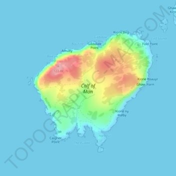
Name: Calf of Man topographic map, elevation, terrain.

Location: Calf of Man, Rushen, Isle of Man (54.04385 -4.83085 54.06172 -4.79938)

Average elevation: 16 m

Minimum elevation: -1 m

Maximum elevation: 123 m

Other topographic maps

Click on a map to view its topography, its elevation and its terrain.

Colby

Isle of Man > Rushen

Colby, Rushen, Isle of Man

Average elevation: 57 m

Derbyhaven

Isle of Man > Rushen > Malew

Derbyhaven, Malew, Rushen, Isle of Man

Average elevation: 8 m

Silverburn

Isle of Man > Rushen > Malew > Ballasalla

Silverburn, Ballasalla, Malew, Rushen, Isle of Man

Average elevation: 20 m

Ballasalla

Isle of Man > Rushen > Malew

Ballasalla, Malew, Rushen, Isle of Man

Average elevation: 39 m

Port Erin

Isle of Man > Rushen

Port Erin, Rushen, Isle of Man

Average elevation: 52 m