Geolocate

Borgosesia topographic map

Interactive map

Click on the map to display elevation.

About this map

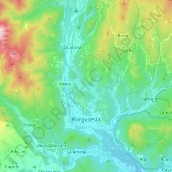
Name: Borgosesia topographic map, elevation, terrain.

Location: Borgosesia, Vercelli, Piedmont, 13011, Italy (45.69415 8.17963 45.77695 8.32021)

Average elevation: 608 m

Minimum elevation: 308 m

Maximum elevation: 1,558 m

Other topographic maps

Click on a map to view its topography, its elevation and its terrain.

Alpe sn14

Italy > Piedmont > Vercelli > Boccioleto > Sella Bassa

Average elevation: 1,365 m

Lago Bowditch

Italy > Piedmont > Vercelli > Alagna Valsesia

Average elevation: 2,745 m

Sn3

Italy > Piedmont > Vercelli > Boccioleto

Average elevation: 1,227 m

Fontana dello Zolfo

Italy > Piedmont > Vercelli > Trino

Average elevation: 149 m

San Gottardo

Italy > Piedmont > Vercelli > Rimella

Average elevation: 1,534 m

sn3

Italy > Piedmont > Vercelli > Rassa

Average elevation: 1,833 m

Mollie

Italy > Piedmont > Vercelli > Cellio con Breia > Mollie

Average elevation: 538 m