
City of Plattsburgh topographic map
Interactive map
Click on the map to display elevation.
About this map
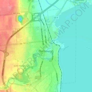
Name: City of Plattsburgh topographic map, elevation, terrain.
Location: City of Plattsburgh, Clinton County, New York, United States (44.66715 -73.48399 44.72467 -73.42916)
Average elevation: 50 m
Minimum elevation: 23 m
Maximum elevation: 109 m
Other topographic maps
Click on a map to view its topography, its elevation and its terrain.
Town of Plattsburgh
United States > New York > Clinton County
Town of Plattsburgh, Clinton County, New York, 12902, United States
Average elevation: 106 m
Town of Champlain
United States > New York > Clinton County
Town of Champlain, Clinton County, New York, United States
Average elevation: 55 m
Catfish Bay
United States > New York > Clinton County > Champlain
Catfish Bay, Champlain, Clinton County, New York, 12979, United States
Average elevation: 31 m
Dannemora
United States > New York > Clinton County > Dannemora
Dannemora, Clinton County, New York, 12929, United States
Average elevation: 445 m