Geolocate

Town of Champlain topographic map

Interactive map

Click on the map to display elevation.

About this map

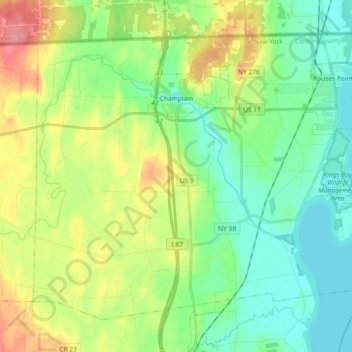
Name: Town of Champlain topographic map, elevation, terrain.

Location: Town of Champlain, Clinton County, New York, United States (44.90475 -73.52150 45.01072 -73.33796)

Average elevation: 55 m

Minimum elevation: 27 m

Maximum elevation: 108 m

Other topographic maps

Click on a map to view its topography, its elevation and its terrain.

Town of Plattsburgh

United States > New York > Clinton County

Town of Plattsburgh, Clinton County, New York, 12902, United States

Average elevation: 106 m

City of Plattsburgh

United States > New York > Clinton County

City of Plattsburgh, Clinton County, New York, United States

Average elevation: 50 m

Catfish Bay

United States > New York > Clinton County > Champlain

Catfish Bay, Champlain, Clinton County, New York, 12979, United States

Average elevation: 31 m

Dannemora

United States > New York > Clinton County > Dannemora

Dannemora, Clinton County, New York, 12929, United States

Average elevation: 445 m