
Artesa de Segre topographic map
Interactive map
Click on the map to display elevation.
About this map
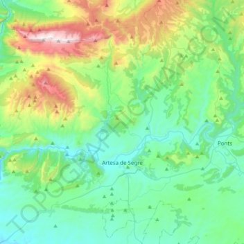
Name: Artesa de Segre topographic map, elevation, terrain.
Location: Artesa de Segre, Noguera, Lerida, Catalonië, 25730, Spanje (41.81280 0.95499 42.06210 1.17130)
Average elevation: 585 m
Minimum elevation: 276 m
Maximum elevation: 1,663 m
Other topographic maps
Click on a map to view its topography, its elevation and its terrain.
Coll de Comiols
Spanje > Catalonië > Noguera > Artesa de Segre
Coll de Comiols, Artesa de Segre, Noguera, Lerida, Catalonië, 25730, Spanje
Average elevation: 1,029 m