
Folsom topographic map
Click on the map to display elevation.
Folsom
Carpenter Hill in Folsom has the highest elevation in Sacramento County.
About this map
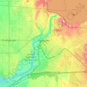
Name: Folsom topographic map, elevation, terrain.
Location: Folsom, Sacramento County, California, United States (38.61044 -121.21010 38.71736 -121.07908)
Average elevation: 90 m
Minimum elevation: 21 m
Maximum elevation: 217 m
Other topographic maps
Click on a map to view its topography, its elevation and its terrain.
William B. Pond Recreation Area
United States > California > Sacramento County
Average elevation: 21 m
Walnut Grove
United States > California > Sacramento County
Walnut Grove's location has made it the site of a rare collection of very tall radio and television transmission towers. The first major tower here was the KXTV/KOVR/KCRA Tower built in 1962, which dominated the skyline for over twenty years with its 1,548 foot height. In 1985 the old tower was joined by…
Average elevation: 1 m
Natomas Main Drainage Canal
United States > California > Sacramento County > Sacramento
Average elevation: 7 m
Rancho Murieta
United States > California > Sacramento County > Rancho Murieta
Average elevation: 91 m