
Make a donation
Gear up for your next adventure:
As an Amazon Associate, this site earns from qualifying purchases at no extra cost to you.
Lindesnes fyr topographic map
Click on the map to display elevation.
Make a donation
Gear up for your next adventure:
As an Amazon Associate, this site earns from qualifying purchases at no extra cost to you.
Lindesnes fyr
Lindesnes Lighthouse (Norwegian: Lindesnes fyr) is a coastal lighthouse at the southernmost tip of Norway, about 10 kilometres (6.2 mi) southwest of the village of Høllen in Lindesnes municipality in Agder county. The present lighthouse was built in 1915, although the station was first built in 1656 to mark the entrance to the Skaggerak and the Baltic Sea from the North Sea. The current 16.1-metre (53 ft) tall lighthouse is cast iron with a granite foundation. The lighthouse is painted white, with a red top. The light sits at an elevation of 50.1 metres (164 ft) and it emits a fixed and flashing white light that is always on and it rotates between a low intensity and high intensity light every 20 seconds. The light comes from a first order Fresnel lens that can be seen for up to 17.7 nautical miles (32.8 km; 20.4 mi).
Make a donation
Gear up for your next adventure:
As an Amazon Associate, this site earns from qualifying purchases at no extra cost to you.
About this map
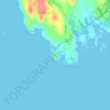
Name: Lindesnes fyr topographic map, elevation, terrain.
Location: Lindesnes fyr, Fyrstien, Lindesnes, Agder, Norway (57.98245 7.04662 57.98255 7.04672)
Average elevation: 10 m
Minimum elevation: 0 m
Maximum elevation: 104 m
Make a donation
Gear up for your next adventure:
As an Amazon Associate, this site earns from qualifying purchases at no extra cost to you.
Other topographic maps
Click on a map to view its topography, its elevation and its terrain.
Make a donation
Gear up for your next adventure:
As an Amazon Associate, this site earns from qualifying purchases at no extra cost to you.
Make a donation
Gear up for your next adventure:
As an Amazon Associate, this site earns from qualifying purchases at no extra cost to you.
Make a donation
Gear up for your next adventure:
As an Amazon Associate, this site earns from qualifying purchases at no extra cost to you.
Make a donation
Gear up for your next adventure:
As an Amazon Associate, this site earns from qualifying purchases at no extra cost to you.
Make a donation
Gear up for your next adventure:
As an Amazon Associate, this site earns from qualifying purchases at no extra cost to you.
Make a donation
Gear up for your next adventure:
As an Amazon Associate, this site earns from qualifying purchases at no extra cost to you.