
Farsund topographic map
Click on the map to display elevation.
About this map
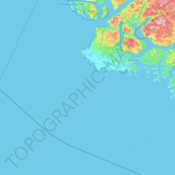
Name: Farsund topographic map, elevation, terrain.
Location: Farsund, Agder, Norway (57.81889 6.16451 58.23057 7.00142)
Average elevation: 25 m
Minimum elevation: -1 m
Maximum elevation: 485 m
Other topographic maps
Click on a map to view its topography, its elevation and its terrain.
Lindesnes fyr
Lindesnes Lighthouse (Norwegian: Lindesnes fyr) is a coastal lighthouse at the southernmost tip of Norway, about 10 kilometres (6.2 mi) southwest of the village of Høllen in Lindesnes municipality in Agder county. The present lighthouse was built in 1915, although the station was first built in 1656 to mark…
Average elevation: 10 m